
Monday Morning Weather Update — December 15, 2025
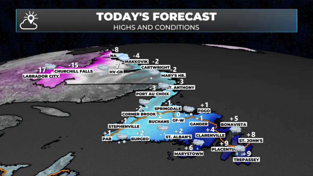
Good Monday morning!
We are in the midst of another major winter storm as we begin this new workweek. Snow is currently falling across much of the Island, but as of 4:45 AM, the snow has changed to freezing rain or rain across a large portion of southeastern Newfoundland—meaning the Avalon and Burin Peninsulas. The radar image(s) from below illustrate that well.
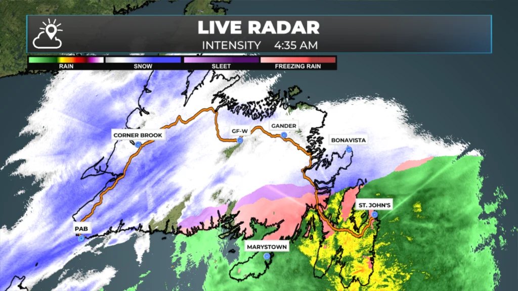
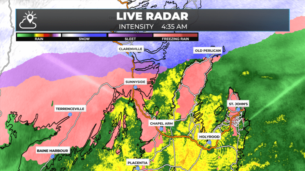
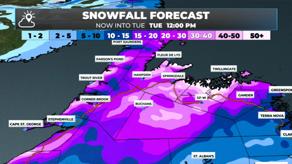
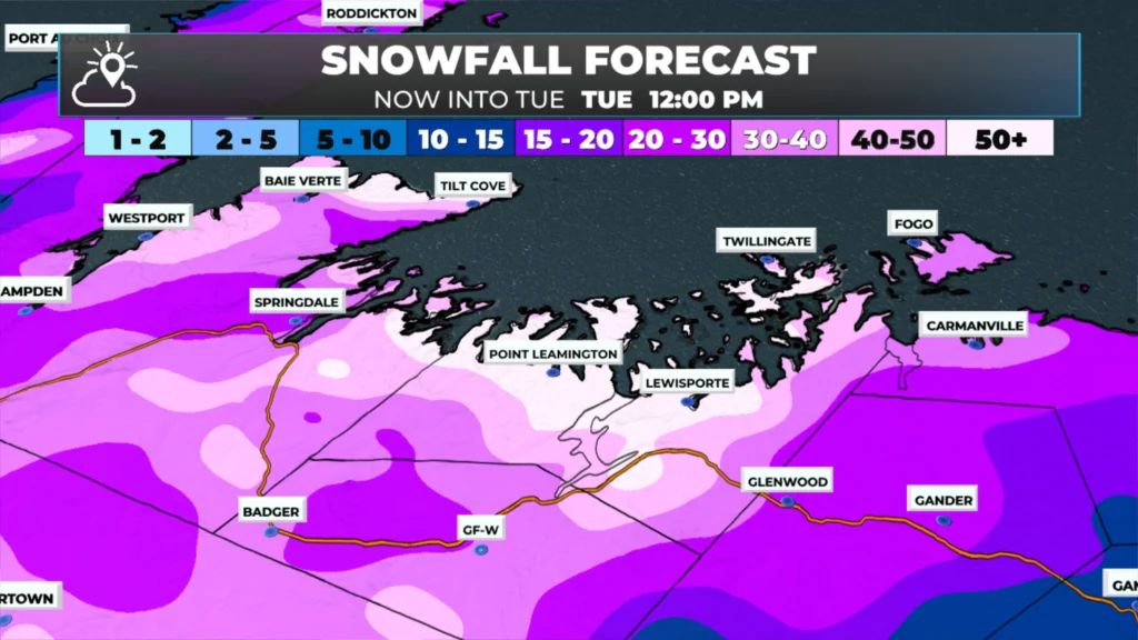
What will be interesting to watch throughout the day is how far west the rain/snow line moves. Current forecasts indicate that it will move into northeastern Newfoundland, get very, very close to Gander, and run on a diagonal line southeast to near Harbour Breton. If that rain/snow line does make it into Gander, that would cut down on the expected snowfall totals there. Amounts will be closer to 30 cm than 50+.

The Environment and Climate Change Canada Weather Office in Gander has made changes to the current alerts in effect, as follows (broken down by type, colour, and region).
🟡 Yellow Level – Winter Storm Warnings
Impact: Moderate | Confidence: High
Regions affected:
Northern Peninsula East
Bay St. George
Corner Brook and vicinity
Deer Lake – Humber Valley
Gros Morne
Grand Falls-Windsor and vicinity
Buchans and the Interior
Summary impacts:
Snow at times heavy with blowing snow
Blizzard-like conditions developing tonight in some areas
Near-zero visibility at times
Travel disruptions and possible utility interruptions
Expected conditions:
Snowfall: Generally 20–35 cm (locally near 25–35 cm)
Wind gusts:
Northeasterly 70–90 km/h today
Becoming northwesterly 90–110 km/h tonight
Timing: Ongoing today through Tuesday morning
🟠 Orange Level – Winter Storm Warnings
Impact: High | Confidence: High
Regions affected:
Gander and vicinity
Bay of Exploits
Bonavista North
Summary impacts:
Prolonged blizzard-like conditions
Widespread near-zero visibility in blowing snow
High likelihood of school closures and service disruptions
Risk of extended power outages
Expected conditions:
Snowfall:
Gander: near 30 cm
Bay of Exploits & Bonavista North: 30–40 cm (locally higher)
Wind gusts:
Northeasterly up to 80 km/h today
Strengthening to northwesterly 110–130 km/h tonight
Timing: Continuing through Tuesday morning
🟡 Yellow Level – Blowing Snow Advisory
Impact: Moderate | Confidence: High
Regions affected:
Parsons Pond – Hawke’s Bay
Port Saunders and the Straits
Summary impacts:
Widespread blowing snow
Near-zero visibility at times
Hazardous travel conditions
Expected conditions:
Snowfall: 15–20 cm
Wind gusts:
Northeasterly near 70 km/h
Shifting to northwesterly near 80 km/h
Timing: Monday morning through early Tuesday morning
This update is sponsored by Roebothan, McKay, Marshall.

Visit MakeTheCall.ca TODAY to learn more about what the law firm can do for you.
Future satellite and radar imagery (below) should give you a good idea of how the rain, snow, and ice will unfold across Newfoundland today. I suggest avoiding all non-essential travel in areas that are not expected to change to rain, as blizzard conditions will make travel difficult at best and downright dangerous at worst.
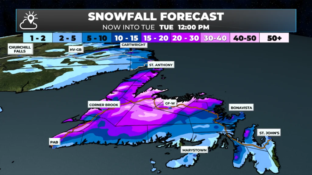
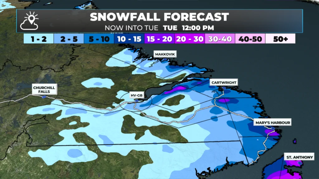
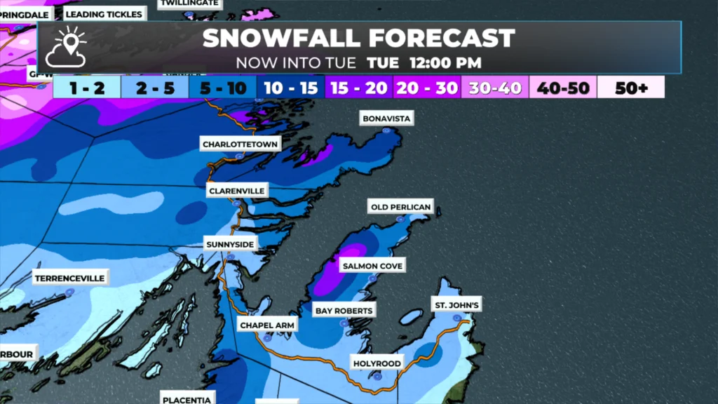
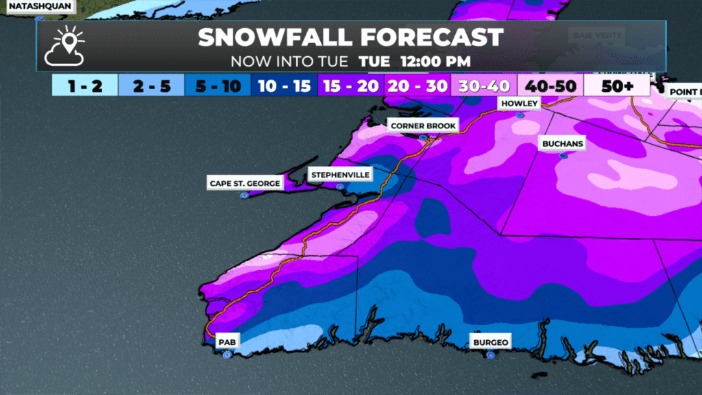
Snowfall totals today will vary by location, but overall, we are looking at widespread 20 to 40+ cm across a large swath of the western half of Newfoundland between last night and early tomorrow. Some eastern areas that see a change to rain today will see another round of snow this evening. That second round may be significant to parts of the northeast coast, Bonavista, and the Avalon Peninsula, depending on where exactly it sets up.
Keep in mind that with systems like this, there are often details that computers get wrong, such as the placement of the heaviest snowfall. Rapidly developing lows are hard to track in areas with extensive atmospheric data; we don’t have that luxury in NL!
The other facets of this storm will be the wind. A period of very high winds is expected over much of central, northeast, and eastern Newfoundland from this evening into the overnight period. There is the potential that areas along Notre Dame, Bonavista, Trinity, and Conception Bays see gusts over 120 km/h tonight. Wind Warnings are in effect for the following areas:
🟠 Orange Level – Wind Warnings
Impact: High | Confidence: High
Regions affected:
St. John’s and vicinity
Avalon Peninsula North
Bonavista Peninsula
Summary impacts:
Severe and damaging wind gusts
Risk of tree damage, roof and fence damage
Likely power outages and transportation disruptions
Expected conditions:
Wind gusts: West to northwesterly 130–140 km/h
Timing: Near midnight tonight through early Tuesday morning
🟡 Yellow Level – Wind Warnings
Impact: Moderate | Confidence: High
Regions affected:
Avalon Peninsula Southeast
Avalon Peninsula Southwest
Clarenville and vicinity
Terra Nova
Burin Peninsula
Connaigre
Summary impacts:
Strong winds capable of causing localized damage
Potential utility interruptions and travel issues
Expected conditions:
Wind gusts: West to northwesterly 110–120 km/h
Timing: Tonight through early Tuesday morning
Something of note is that the Winter Storm Warnings (above) also account for the high winds expected along parts of coastal Newfoundland from Green Bay to Cape Freels. The animation below shows wind gusts for today through tonight. Keep in mind this is model data, and I think it may be too low for parts of the Avalon, where there is some discrepancy in the peak winds. This data suggests peaks near 100, but the pentila indicates gusts exceeding 120 km/h. If that is the case, the peak will be at the same time, around midnight.
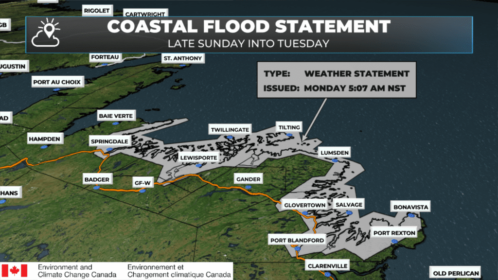
The last thing of note is the risk of coastal flooding tonight. Storm surge and large waves may impact the northeast coast of Newfoundland from Green Bay to Bonavista Bay late tonight into Tuesday morning, with the greatest risk around high tide (4:00–6:00 a.m.). Waves of 7–9 metres combined with storm surge could cause localized coastal damage, especially where water levels approach or exceed the highest astronomical tide.
I’ll have updates throughout the day. Use the links below or find me on my socials to see them!
I’ll have my next update posted later today!
📱 Get the Sheerr Weather App in the Apple App Store and Google Play Store.
🗺️ Check out the Map Room to see all the latest weather observations for the Province.
🎥 Check out the Provincial Highway Cams to see 👀 what’s going on around our highways and
Thanks Eddie!
🙂
Good morning Eddie, thanks for weather update.
Thank you for the updates Eddy. Stay safe:)
Thank you Eddy, have a safe day
Thanks Eddie, now we just wait it out🤪
Thank you.
Thanks Eddie for the update….
Thanks Eddie for all the updates and have a great day.😘