
Tuesday Morning Weather Update — December 16, 2025

Forecasts, alerts & live weather for Newfoundland and Labrador
The animation above shows the position of the low-pressure centre that brought us yesterday’s rain, snow, and wind.
The winds were ferocious overnight as the forecasts came to fruition. Many areas of the Island saw extremely high wind speeds overnight. Just after midnight, St. John’s International Airport reported a sustained wind of 103 km/h and gusts to 137 km/h. The sustained wind looks to be a new record.
Per yyt climate normals, the sustained wind at 0030 nst (103 km h) is the highest ever observed in December during the period of record (1942-). The peak wind gust of 137 km h is the highest observed in December in the current climate normals period (1991-). #nlwx
— Nicholas Camizzi (@thecamizzx) December 16, 2025
Several other locations experienced very high wind speeds overnight, resulting in reports of damage to homes and sheds, and even one report of a wood stove chimney blowing off a house in CBS! Luckily, we are now past the high winds and things are calming down… albeit slowly.
Peak Wind Gusts (unofficial):
Argentia: 107
Bonavista: 139
Ferolle Point: 100
Gander Int’l Airport: 107
Pool’s Island: 122
PAB: 102
Sagona Island: 141
St. Anthony: 113
St. John’s Int’: 137
St. Lawrence: 106
Winterland (Marystown): 107
The other side of this was blizzard conditions in parts of western, central, and northeastern Newfoundland, brought on by high winds and blowing/falling snow last night. The video below is from Appleton, Newfoundland and Labrador, which sits between Gander and Bishop’s Falls.
As of early this morning, Newfoundland Power’s Outage Centre shows a total of nearly 17,000 customers without power.
Chase over. <100m visibility every couple mins with drifting starting. #nlwx pic.twitter.com/LqzMv2yOP9
— Troy Boone (@derecho_series) December 16, 2025
As the weather calms down and the day breaks, we will all get a look at what the wind did last night. Based on the sounds my house was making, I will be shocked if I don’t have any damage.

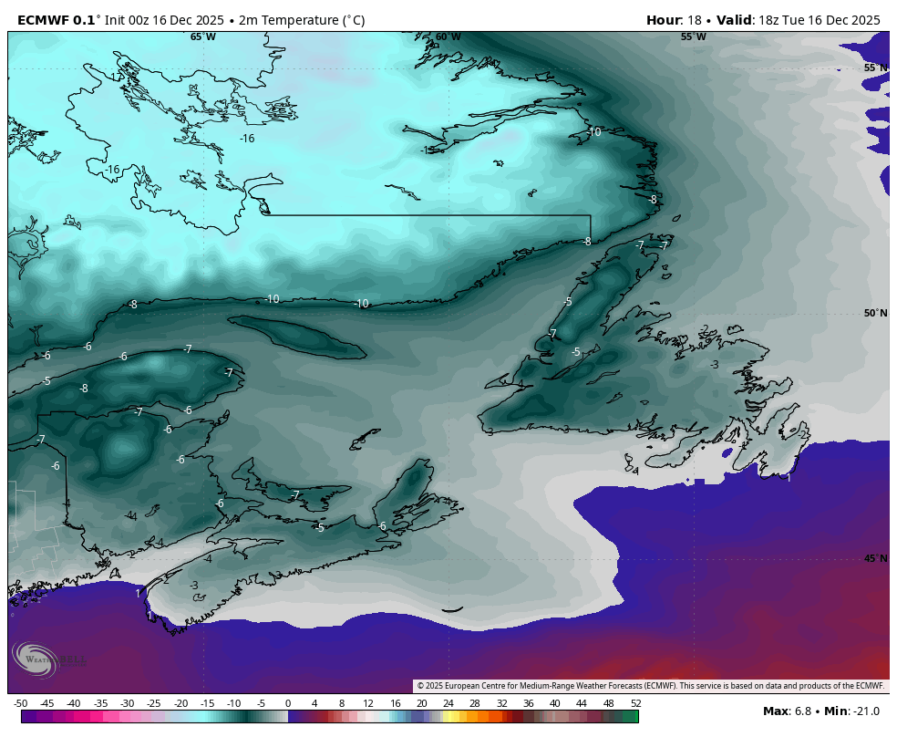
Forecast temperatures this afternoon (December 16, 2025)
The weather today will be much calmer across the region, though we will see gusty winds continue for a while longer as they make their way down and our area of low pressure continues to depart. Expect a mix of sun and clouds across the board outside of the flurries and squalls.
This update is sponsored by Roebothan, McKay, Marshall.

Visit MakeTheCall.ca TODAY to learn more about what the law firm can do for you.
The wind speeds will continue to come down, and today will be a solid day to clean up. Aside from scattered flurries and snow squalls, the weather across the region looks fairly uneventful today. The next system moves in tomorrow, but it will be much weaker. Expect scattered areas of snow and rain on the Island by afternoon and light snow in much of Labrador. Following that, we await the arrival of our next, and warmer, weather-maker for the start of the weekend.
I’ll have my next update posted later today!
📱 Get the Sheerr Weather App in the Apple App Store and Google Play Store.
🗺️ Check out the Map Room to see all the latest weather observations for the Province.
🎥 Check out the Provincial Highway Cams to see 👀 what’s going on around our highways and
By using this website, you agree to our use of cookies. We use cookies to provide you with a great experience and to help our website run effectively. Privacy Policy
Good morning Eddie it was a very wicked evening but nice and calm here today in CBS
Thanks Eddie for weather update
Thanks for the update, Eddie! We had one very large tree fall across our driveway but it narrowly avoided hitting a lamppost which was a blessing.
Good morning Eddie ! It sure was a windy night …. Thanks for the update!
I’ve never experienced anything like it what a wild night here near Hearts Content where westerly winds were 74km/hr gusting at 117km/hr
No damage to my home or property thanks goodness!
Thanks for the updates Eddie we appreciate you!
That was crazy!!!
The wind was ferocious! I thought the house would blow down. Thankfully, it didn’t.