
Friday Morning Weather Update — January 2, 2026
Good Friday Morning!
Here are today’s weather highlights:
Another area of low pressure will pass through Quebec and Labrador West between today and tonight. This means another mild day with rain, snow, and a bit of ice for the Island, and snow in much of Labrador.
Snowfall totals between last night and later tonight from Goose Bay to Labrador West will be on the order of 15 to 30 cm in most areas. Lesser amounts on the east/southeast coast and in the Straits, where rain mixes with the snow.
An area of low pressure will develop and pass east of the Avalon overnight into Saturday, bringing a brief round of heavy snow to eastern Newfoundland Saturday, similar to what we saw Thursday.
A more substantial low will move over or near eastern Newfoundland late Sunday into Monday and has the potential to bring another round of significant snowfall with it.

This update is sponsored by Roebothan, McKay, Marshall.
Visit MakeTheCall.ca TODAY to learn more about what the law firm can do for you.
The system moving through today will be a messy one for the Island, with many areas reaching highs well above the freezing mark, while Labrador will largely see highs below freezing, but it won’t be by much, as unseasonably warm air is in place across the region. Rain will fall for most areas at one point or another today, including on the Great Northern Peninsula.
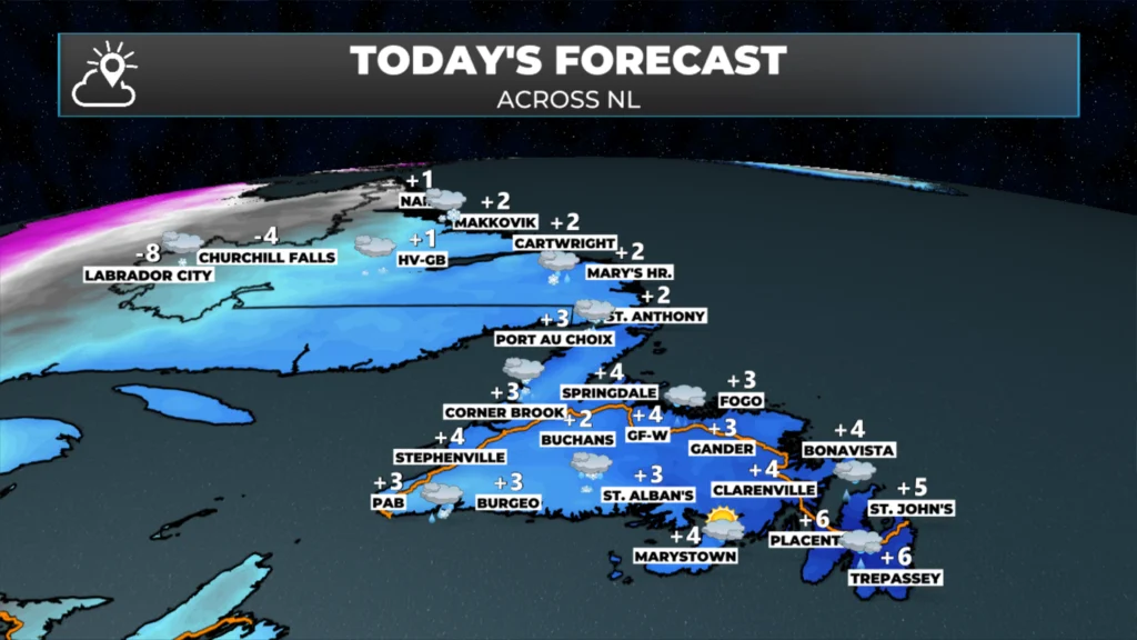
Today’s high and expected conditions — January 2, 2026.
This is due to an area of low pressure moving from the Gulf into eastern Quebec and western Labrador, which pushes air up from the south on its eastern side, and that air is typically warm… and in this case, it’s no different. Future Satellite and Radar imagery shows how today will play out quite well.
Snowfall today will be significant in parts of Labrador, especially from Goose Bay back to Wabush, where it looks like a widespread 15 to 30 cm is in the forecast. The map below shows where the heaviest snow will fall today. Note the drop off in totals in the east and south; that’s due to rain expected there at various times today.
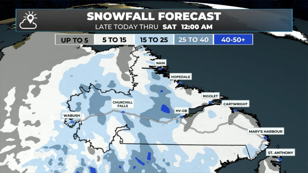
The snowfall forecast thru midnight tonight — January 3, 2026.
The next item(s) in the docket are a round of snow (and rain) for eastern areas of Newfoundland tomorrow. This will be similar to Friday’s system, with the potential for a quick 5 to 15 cm of snow. It looks like the eastern Avalon will see a mix of rain and snow, with snow across the western half and some adjacent areas of eastern Newfoundland. Following that, another winter storm could bring heavy snowfall to a large portion of the Island Sunday into Monday. There is still some uncertainty with this one regarding track and the mix of snow, rain/ice there is, especially in the east. Stay tuned for updates on this one!
I’ll post my next update later today, which will provide more detail on the above.
📱 Get the Sheerr Weather App in the Apple App Store and Google Play Store.
🗺️ Check out the Map Room to see all the latest weather observations for the Province.
🎥 Check out the Provincial Highway Cams to see 👀 what’s going on around our highways and
Good morning ☕️Eddie & thank you the update!
Hope you have a great day
Tks Eddy happy Newyear keep up the good work
Good morning, thanks for the update
Good Morning Eddie! Another frustrating forecast ….. boy oh boy! Thanks for the update
Thank you Eddie
Thank you for the update, Happy New Year!
Happy new year
Eddie I find it difficult to navigate these forecasts. You click on Avalon forecast and there’s more mention of Labrador communities then anything else. People want a very clear forecast for their area, I usually end up leaving your website and then have to check the weather network cause I’m still unclear. Trying to support your endeavour bud
Hey Chris,
I’m not sure I follow what you’re saying. This is a broad overview for the Province. To get a forecast for your area, your best course is either the forecast pages on the website — or just use the app and look up the location you’re wanting the forecast for. Email me anything with questions. Eddie@SheerrWeather.ca
Thank you
Happy New Year Eddie. Thank you for the update. Great work as usual.
Thanks Eddie for weather update