
Monday Morning Update — January 12, 2026
Good Monday Morning!
Here are today’s weather highlights:
A major winter storm will move through the Province between today and early tomorrow.
Wind gusts of 100 to 130 km/h will occur over many areas of the Island this afternoon and evening, and in southern Labrador. This includes the Avalon Peninsula and St. John’s Metro.
Heavy snowfall, freezing rain, rain and high winds will affect many areas of Newfoundland and southern Labrador from today into later tonight.
Travel will be difficult for areas fo central and western Newfoundland, the Northern Peninsula and southeast Labrador until at least early Tuesday.
A surge in temperatures over eastern/southeastern areas will occur this morning, before a cool down this afternoon to sub-freezing temperatures.

This update is sponsored by Roebothan, McKay, Marshall.
Visit MakeTheCall.ca TODAY to learn more about what the law firm can do for you.
The following weather alerts are in effect:
Avalon Peninsula North:
Orange Warning: Wind
Yellow Warning: Blowing Snow
Avalon Peninsula Southeast:
Orange Warning: Wind
Yellow Warning: Blowing Snow
Avalon Peninsula Southwest:
Orange Warning: Wind
Yellow Warning: Blowing Snow
Bonavista North:
Orange Warning: Wind
Yellow Warning: Blowing Snow
Bonavista Peninsula:
Orange Warning: Wind
Yellow Warning: Blowing Snow
Burin Peninsula:
Orange Warning: Wind
Yellow Warning: Rainfall and Blowing Snow Advisory
Clarenville and Vicinity:
Orange Warning: Wind
Yellow Warning: Blowing Snow Advisory
Connaigre:
Orange Warning: Wind
Yellow Warning: Freezing Rain, Rainfall, and Blowing Snow Advisory
Bay of Exploits:
Orange Warning: Wind
Yellow Warning: Blowing Snow
Bay St. George:
Yellow Warning: Winter Storm
Buchins and the Interior:
Yellow Warning: Winter Storm
Burgeo-Ramea:
Orange Warning: Wind
Yellow Warning: Freezing Rain, Rainfall, and Blowing Snow Advisory
Gander and Vicinity:
Orange Warning: Wind
Yellow Warning: Blowing Snow
Grand Falls-Windsor and Vicinity:
Yellow Warning: Winter Storm
Green Bay-White Bay:
Yellow Warning: Winter Storm
Gros Morne:
Yellow Warning: Winter Storm
Norman Bay to Lodge Bay:
Orange Warning: Winter Storm
Northern Peninsula East:
Yellow Warning: Winter Storm
Parsons Pond-Hawke’s Bay:
Yellow Warning: Winter Storm
Port Saunders and the Straits:
Yellow Warning: Winter Storm
Red Bay to L’Anse-au-Clair:
Orange Warning: Winter Storm
St. John’s and Vicinity:
Orange Warning: Wind
Yellow Warning: Blowing Snow Advisory
Terra Nova:
Orange Warning: Wind
Yellow Warning: Blowing Snow Advisory
As of 6:02 AM NST, radar suggests rain is falling over southern and southeastern Newfoundland, while areas north of the South Coast and west of the Avalon are seeing freezing rain (pink). Areas just west of there, almost on a diagonal line between Grand Falls-Windsor and Corner Brook, are seeing a mix of snow and ice pellets, and farther west and north of that, snow is falling. Snow is also falling across the GNP and in southeastern Labrador (radar doesn’t reach that far).
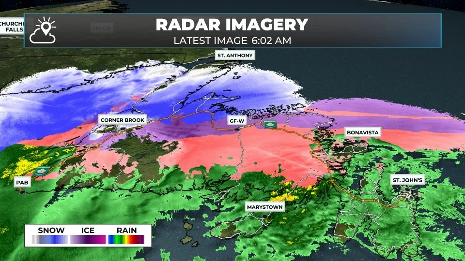
Radar image as of 6:02 AM on January 12, 2026. Tap or click to enlarge.
The low-pressure area driving this storm will strengthen as it crosses the Island today, causing the atmosphere to respond in several ways. First, the rain, ice, and snow will continue this morning; however, as the system occludes (the cold air wraps all the way around the low), we will gradually see the snow return to areas that are currently seeing rain or will see rain, along with mild temperatures this morning.
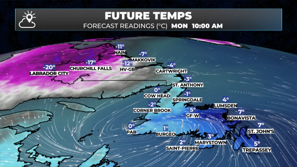
The forecast temperatures at 10 AM today (Jan 12, 2026).
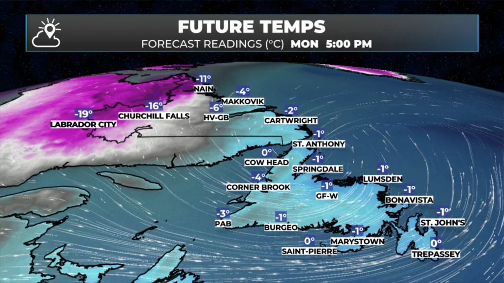
The forecast temperatures at 5 PM today (Jan 12, 2026).
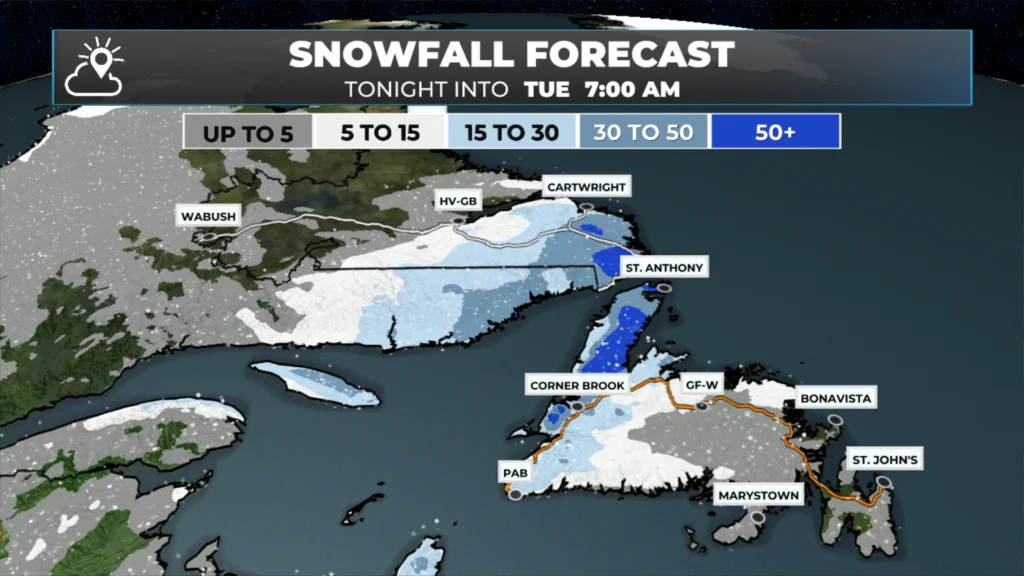
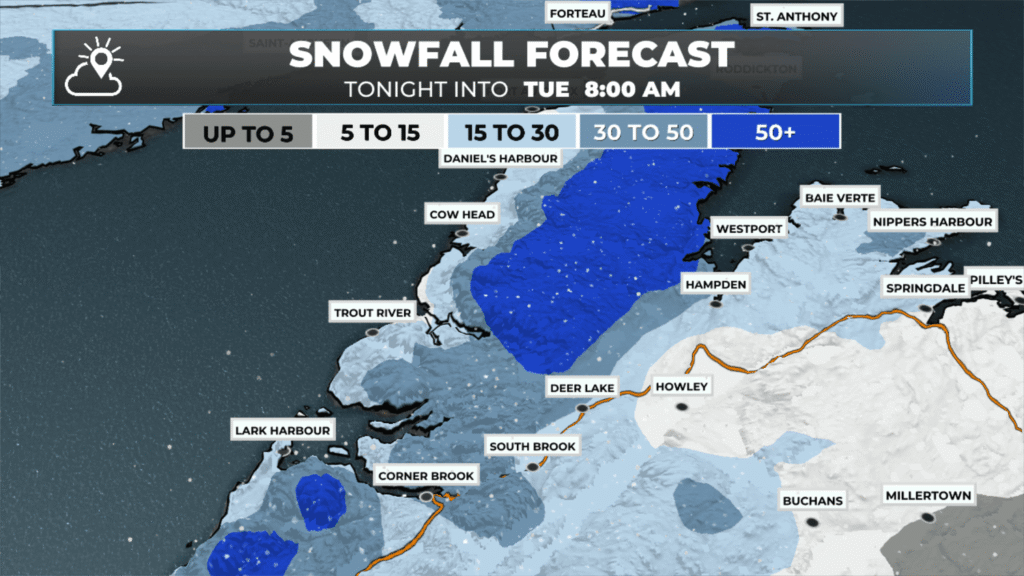
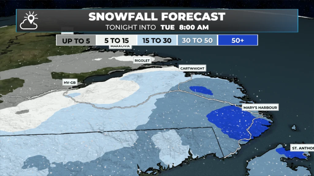
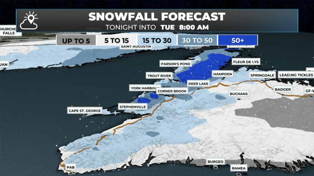
In fact, flurries and snow squalls will develop this afternoon in many of these areas. Second, the West Coast, Northern Peninsula, and southeast Labrador will experience snow persisting throughout the day and into tonight. This region will see the most snowfall, likely near or exceeding 40 cm in some places. Future radar and satellite images show the progression of this quite clearly.
The other major issue with this low will be the wind it develops later today and this evening. The central pressure will drop to about 956 mb as it moves away from central and northeastern Newfoundland and into the North Atlantic this evening. The low pressure will generate a very intense pressure gradient, which is a fancy term for a very large difference in pressure between the atmosphere near the low’s centre and well away from it. This setup can and does often drive some very high winds on the western and southern sides of the low as the air is rushing into the centre of the storm.
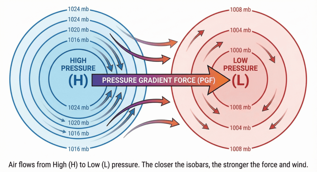
A graphic showing how pressure gradients work and that air flows from high to low pressure.
We’ve seen it several times already this winter, and it will happen again today. Wind gusts from the southern coast of Labrador to the northern peninsula across much of central and eastern Newfoundland will be well over 100 km/h for several hours this afternoon and evening. Eastern areas will take the brunt of this, where exposed locations will see gusts over 120 or 130 km/h. This includes the Avalon Peninsula. The animation below shows how the wind speeds will play out today. However, the speeds here may be too low by 10 to 20+ km/h, especially in the east.
The image below shows the RDPS model’s peak wind gusts forecast between early this morning and later tonight. It doesn’t give you timing (the above does), but it does make my point that I feel strongly the speed forecast above is too low and that many areas will see gusts over 120 km/h. Note that the numbers displayed on the map may not correspond to the closest town or city exactly. Deer Lake and Corner Brook, for instance, will not see wind speeds much above 100 km/h. Exposed areas along and near the coast, however, will.
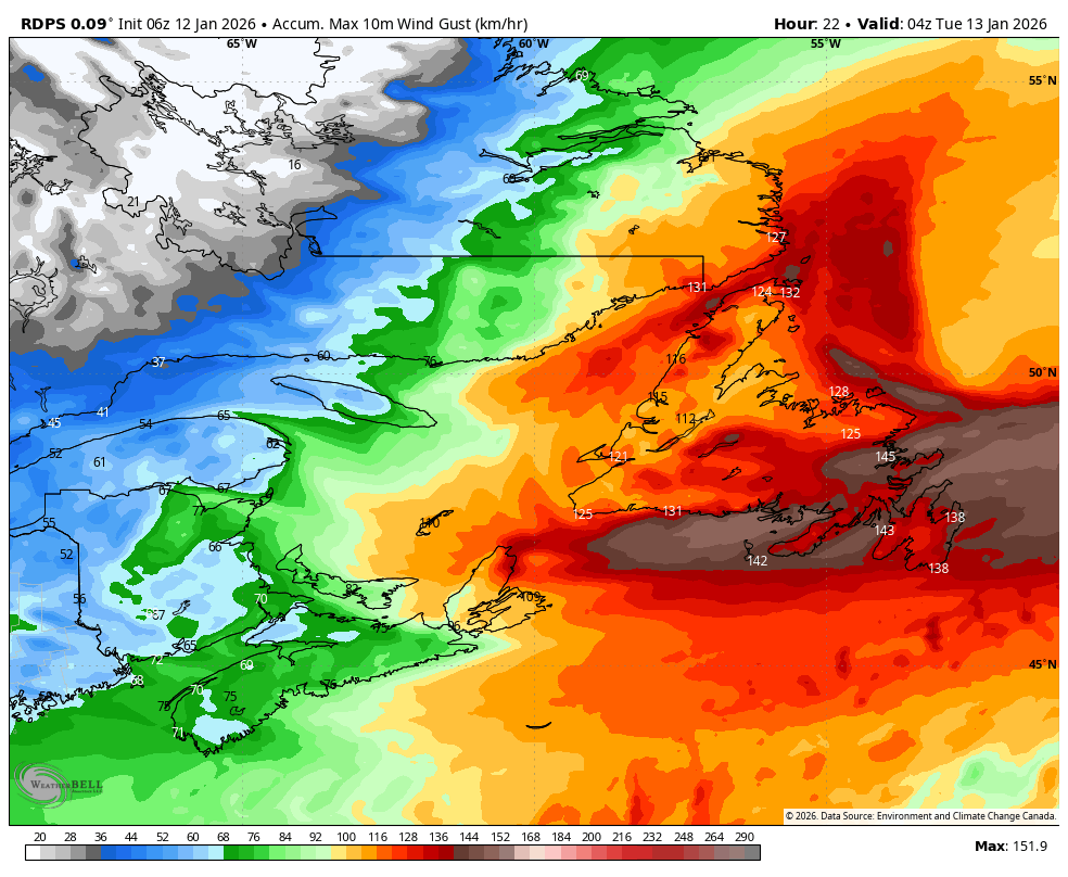
The forecast peak wind speeds from today through early Tuesday morning (RDPS model). Jan 12, 2026. Tap or click to enlage.
Below are images showing the expected snowfall totals from this morning through tomorrow morning. The highest amounts will be on the West Coast, the Northern Peninsula, and in southern Labrador. The least will be over the southern and eastern parts of Newfoundland. Lab West misses out on most of this one! Tap to enlarge each image.
Updates to come throughout the day.
📱 Get the Sheerr Weather App in the Apple App Store and Google Play Store.
🗺️ Check out the Map Room to see all the latest weather observations for the Province.
🎥 Check out the Provincial Highway Cams to see 👀 what’s going on around our highways and
Thanks Eddie
Thank you for your consistent updates
Thanks Eddie. It’s gonna be a hellava day and night! Buckle up everyone! Thanks for the update
Good morning and thanks Eddie have a wonderful day
My wind anxiety is on bust!!! I am terrified of the wind. I look a the wind models and see the number and then read further to see the numbers are lower than what it going to be….Why? This is so nerve racking
Good morning and Thanks for the update….
Good morning Eddie, thanks for weather update.
Thanks Eddie