
Strong Winter Storm Arrives Sunday Night, Winter Storm Watches, Special Weather Statements Issued by Environment Canada
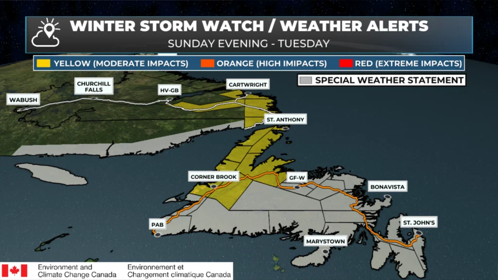
Weather alerts from ECCC NL as of 7:50 AM NST on January 10, 2026.
A powerful winter storm will move across Newfoundland and Labrador between Sunday night and Tuesday morning. This storm is expected to bring rain, freezing rain, snow, and wind to the Province within the forecast period. The heaviest rain will be found over southern and eastern Newfoundland, while the heaviest snow will fall over the West Coast, Northern Peninsula and southeast Labrador. High winds gusts (near or over 100 km/h) will be found along the West Coast, South Coast and east coast of the Island and potentially along parts of Labrador’s southern coast.
Ahead of this weather-maker, the Environment and Climate Change Canada Weather Office in Gander has issued Special Weather Statements and Winter Storm Watches for a large chunk of Newfoundland and Labrador. The details for each alert and the areas included are listed below.
A Yellow Watch – Winter Storm is in effect from overnight Sunday night into Tuesday morning for the following areas of Newfoundland:
Corner Brook and vicinity
Deer Lake – Humber Valley
Green Bay – White Bay
Gros Morne
Parson’s Pond – Hawke’s Bay
Port Saunders and the Straits
Northern Peninsula East
When: Sunday night into early Tuesday morning.
Potential Snowfall: 15 to 35 cm
Wind Gusts:
Monday: East to northeast gusts of 90 to 100 km/h, with potentially higher gusts in areas prone to enhanced easterlies near Parson’s Pond River and St. John’s Bay.
Monday Night: North to northwest gusts of 90 to 120 km/h.
The snow may max with or change to ice pellets over areas along the west coast of the Peninsula. The combination of strong winds is likely to result in blizzard-like conditions with poor visibility.
Consider modifying any travel plans, and if travel is necessary, allow lots of extra time to reach your destination. Roads and walkways will be difficult to navigate, and travel delays and/or cancellations are possible.
Winter Storm Watches are issued when hazardous winter weather conditions are possible.
A Yellow Watch – Winter Storm is in effect for the following areas from Monday morning until early Tuesday morning.
Red Bay to L’anse-au-Clair
Norman Bay to Lodge Bay
Cartwright to Black Tickle
Eagle River
When: Monday Morning until early Tuesday morning.
Potential Snowfall: 15 to 30 cm
Wind Gusts: Northeasterly shifting to northwest at 80 to 100 km/h.
Strong winds and heavy snowfall are expected. The combination of fresh snow and strong winds is likely to result in blizzard-like conditions with poor visibility. Roads and walkways will be difficult to navigate. Csondier rescheduling travel nd outdoor activities.
Winter Storm Watches are issued when hazardous winter weather conditions are possible.
A Special Weather Statement is in effect for the following areas for Sunday night into early Tuesday morning for the following areas:
Avalon Peninsula North
Avalon Peninsula Southwest
Avalon Peninsula Southeast
St. John’s and vicinity
Burin Peninsula
Clarenville and vicinity
Bonavista Peninsula
Connaigre
When: Sunday night into early Tuesday morning
Potential Snowfall: 5 to 10 cm
Potential Freezing Rain and Ice Pellet duration: 3 to 6 hours
Potential Freezing Rain amounts: 5 to 10 mm
Potential Rainfall: 15 to 40 mm
Potential Wind Gusts:
Monday morning: Southeast as high as 80 km/h.
Monday afternoon until Tuesday: West to Southwest as high as 90 to 120 km/h along parts of the coast.
Snow will develop Sunday night and quickly transition to a period of ice pellets and freezing rain, then to rain before sunrise Monday morning. Rainfall will be significant in some areas.
Subsequent snowmelt and rain will lead to water pooling on roads and localized flooding in low-lying areas.
Temperatures will fall below freezing again on Monday afternoon, causing roads and sidewalks to become icy. Snow squalls are also possible over southern areas and the Avalon Peninsula on Monday afternoon and night.
A Special Weather Statement is in effect for the following areas from Sunday night until Tuesday morning:
Bonavista North
Terra Nova
Gander and vicinity
Grand Falls-Windsor and vicinity
Bay of Exploits
Buchans and the interior
Burgeo – Ramea
Channel-Port aux Basques
Bay St. George
When: Sunday night until early Tuesday morning
Potential Snowfall: 5 to 10 cm
Potential Freezing Rain and Ice Pellets Duration: 6 to 8 hours
Potential Freezing Rain Amounts: 5 to 10 mm, highest inland over higher terrain
Potential Rainfall: 5 to 15 mm in the south and southwest
Wind Gusts:
Sunday night and Monday Morning: East to southeast as high as 80 km/h, except 100 km/h on parts of the coast. Higher gusts are likely in areas prone to enhanced east to southeasterlies, such as the vicinities of Wreckhouse, Cape St. George and Port au Port Bay.
Monday afternoon until Tuesday: South to southeasterly at 80 to 100 km/h, except 120 km/h along parts of the coast.
While precipitation amounts may remain below warning criteria in some areas, this combination of weather conditions is likely to cause a significant disruption to travel and daily activities.
Precipitation will start as snow Sunday night, before changing to ice pellets and freezing rain and rain Monday morning as temperatures rise above freezing. Temperatures will then fall back below freezing on Monday afternoon, and rain may end as snow.
The falling temperatures will cause roads and walkways to become icy and slippery as standing water freezes.
Consider adjusting travel plans to avoid the most adverse conditions. Avoid overexertion when shovelling ice pellets and heavy, wet snow. It is a leading cause of winter-related health emergencies.
Subsequent rain and snowmelt could lead to water pooling on roads and localized flooding in areas with poor drainage.
💨 Find the latest weather alerts in the Storm Centre!
📱 Get the Sheerr Weather app!
🚗 Check out the Highway Camera page!
🗺️ Don’t Forget about the Map Room!
Good morning Eddie have a great day and thanks for keeping us updated
That’s going to be quite the mess Eddie !!!
Thank you for the very detailed update.
Good Morning Eddie!
It’s been a long stretch of “ALL KINDS OF WEATHER’ but not so much GOOD weather. Oh what I’d give to have a nice sunny day!!!!
Thanks for the update!
Tks Eddie for all the detailed weather updates.
Thanks for weather update
Good morning Eddie, thanks for the update. Have a great weekend.
Oh my! Supposed to have left on the ferry this weekend 👀looks like that’s not happening for awhile.
Thanks Eddie!
Looks like a mess to me. Stock up on ice melt for Monday here in town!
Eddie, why is this winter’s weather so much different from the weather we received last winter? Are we into some sort of different weather pattern across North America?
Good morning Eddie! Thanks for the update
Very active weather! Thanks Eddie