
Wednesday Morning Update — January 14, 2026
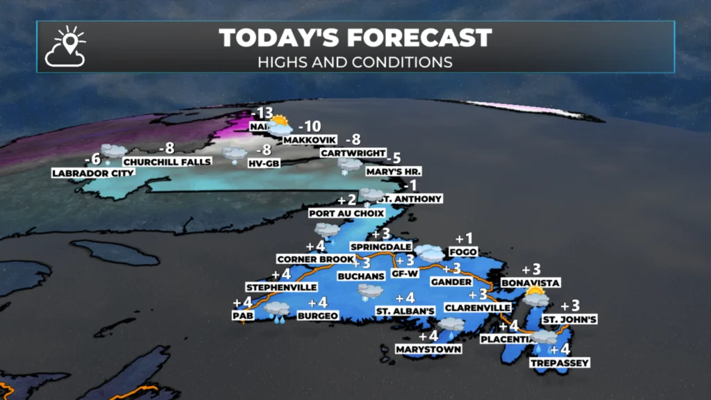
Today’s forecast for NL — January 14, 2026.
Good Wednesday Morning!
Here are today’s weather highlights:
The day starts dry, but snow will move into Labrador and push north and east through the day.
Snowfall will be 5 cm or less.
Snow and/or rain arrives in southern and southwest Newfoundland this morning and will continue to push north and east through the day.
Western, Central, and Eastern areas will see snow arrive late morning or early afternoon, then quickly change to rain. Eastern areas may not even see any flakes.
The Northern Peninsula will see snow arrive midday, then transition to rain or drizzle this evening.
Snowfall will be 5 cm or less.
A Wreckhouse Wind Warning is in effect for Thursday afternoon and evening for gusts as high as 100 km/h from the southeast.
A Yellow Alert – Rainfall is in effect from Connaigre to Port aux Basques for up to 80 mm between Thursday and Friday.

This update is sponsored by Roebothan, McKay, Marshall.
Visit MakeTheCall.ca TODAY to learn more about what the law firm can do for you.
Today, we can expect snow and rain to arrive on the island this morning or early afternoon. In most areas, any frozen precipitation will quickly change to rain. The exception will be on the Northern Peninsula, where snow arrives this afternoon and will continue into the evening before ending as drizzle. Meanwhile, Labrador will see periods of snow today. The snow arrives this morning in the west and will steadily trudge eastward throughout the day. Snowfall amounts in all areas will be 5 cm or less today. Highs on the island will reach the single digits above freezing, and highs in Labrador will reach the single digits below.
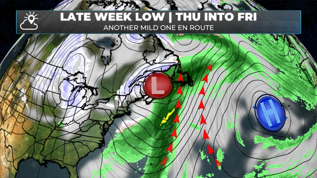
The large-scale setup for the second half of this week.
The weather pattern we are getting into over the next few days will be mild. Much of the Island and even parts of southern Labrador will see a solid 24 to 48 hours of temperatures above freezing beginning this morning. The reason for the change is the position of the jet stream and upper-air pattern. This will cause an area of low pressure to move from south to north across Quebec and Labrador West, while an abnormally strong area of high pressure is centred over the middle of the Atlantic. The setup puts much of our region into a broad southerly flow, which pushes unseasonably warm air northward.
The forecast for tomorrow and Friday (below) should give you a good idea of just how warm it will get.
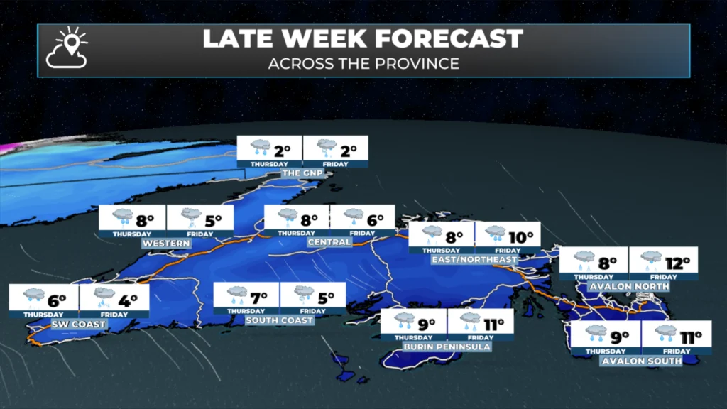
The two day forecast for Newfoundland.
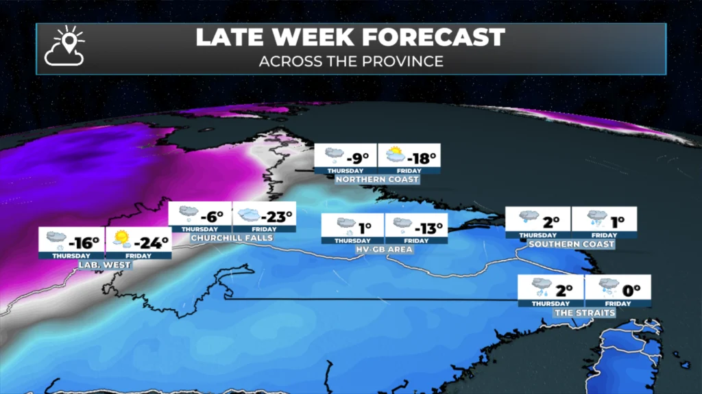
The two day forecast for Labrador.
This pattern will set the stage for significant snowmelt and rain across a large chunk of Newfoundland from today into late Friday. Southern areas of the Island are at risk for seeing as much as 80 mm of rain, and the Environment and Climate Change Canada Weather Office in Gander has issued a Yellow Warning – Rainfall from Connaigre to Port aux Basques.
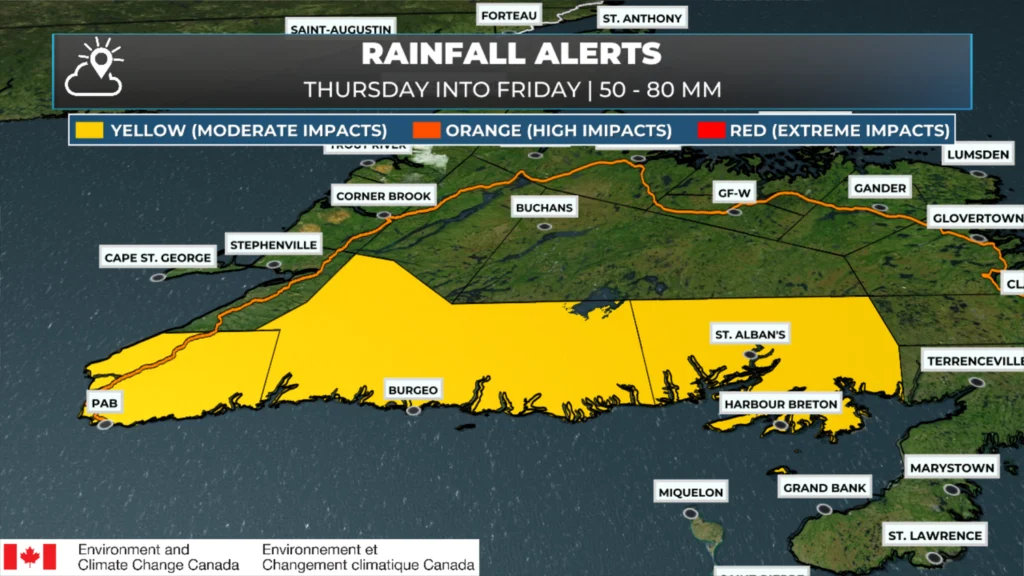
Yellow Warning – Rainfall for southern areas of Newfoundland, west of the Burin Peninsula.
I expect more rainfall alerts to be issued for the Thursday/Friday time frame later today. It also looks like we may be in for yet another round of high winds later Friday into Saturday across southern and eastern Newfoundland, although the speeds do not look as high as what we just had.
Updates to come throughout the day.
📱 Get the Sheerr Weather App in the Apple App Store and Google Play Store.
🗺️ Check out the Map Room to see all the latest weather observations for the Province.
🎥 Check out the Provincial Highway Cams to see 👀 what’s going on around our highways and
Good morning Eddie☕️…Thank you for the weather update!
Have a great day!
Good morning, thanks for the update
Good morning Eddie thanks for the update and have a wonderful day
Thanks for weather update Eddie
Good Morning Eddie! Finally, a couple of days of warmer temps, wind speeds, not so much! We’ve got to take it as it comes. Thanks for the update Eddie.
Good Afternoon Eddy.Thank You For The Weather Update.You Have A Great Day.
Thanks Eddie for weather update