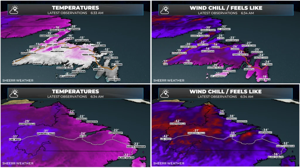
Temperatures and wind chills as of 6:36 AM NST. Tap to enlarge.
Good Monday morning!
Here are today’s weather highlights:
Less breezy across the Province today, with virtually no snow flurry and/or snow squall activity.
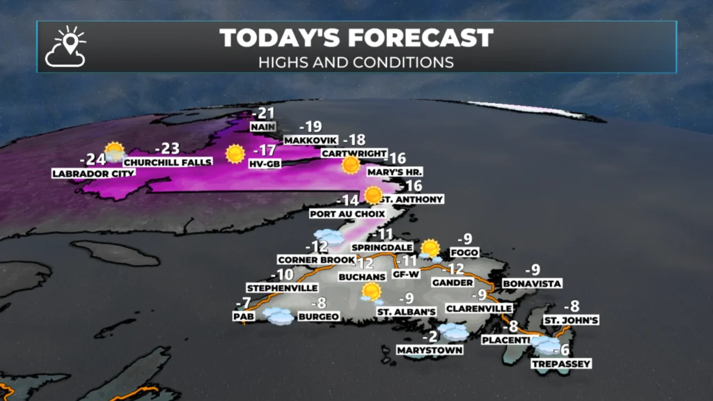
Cold with highs on the Island between -8ºC to -12ºC, except near -17º on the Northern Peninsula. Wind chills in the minus teens, twenties and thirties.
Highs in Labrador between -20ºC and -30º, with wind chills in the minus thirties and forties.
Mostly cloudy to mostly sunny skies will be the rule today.
Snow will spread across much of Newfoundland overnight and on Tuesday, with significant accumulations in many areas. The highest amounts will occur in the southeast and east (metro included) where over 20 cm is likely.
A Yellow Level Winter Storm Warning is in effect for Connaigre and Burgeo – Ramea for Tuesday… I expect more widespread alerts for Tuesday to be issued later today
Sponsored
Today’s Outlook
After a bitterly cold weekend across the Province, temperatures will be somewhat warmer today, but not by much. An area of high pressure will keep the Arctic air in place across the region, with highs only reaching the minus twenties at their warmest in Labrador, and -10º to about -17º on the Island.
Today’s forecast highs – Jan 26, 2026. Tap to enlarge.
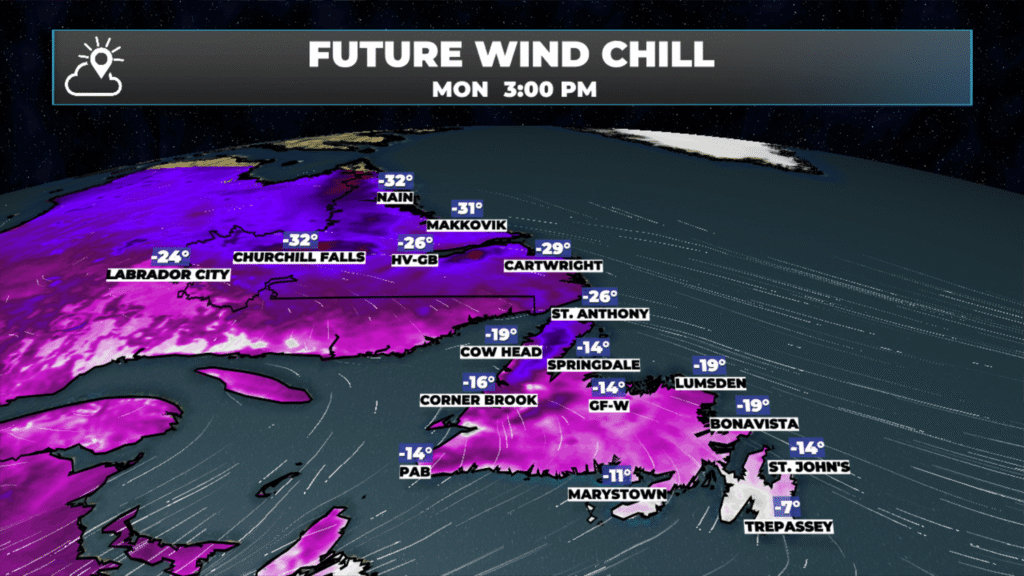
Wind chills will not be as low today, as wind speeds will be lower, thanks to the high-pressure centre over Labrador. Expect a mix of sun and cloud, to mostly cloudy skies, across the board today, with virtually no snow squall or flurry activity.
Today’s forecast wind chills. Jan 26, 2026. Tap to enlarge.
So far as travel days in the winter go, this is a decent one… in NL at least.I say NL because there is a storm system to our south today. This is the same system that brought a punishing amount of snow and ice to the northeastern United States, and parts of Ontario and Quebec yesterday. It looks as though Toronto may have seen one of its biggest snowfalls on record due, in part, to this winter storm and in part to Lake Effect Snow. Reports suggest close to 50 cm fell in parts of the GTA!
Historic. Now at 17inches on the Scarb/East York boarder. It's just relentless, hasn't even slowed for a min. You don't see many of these, this is crazy locally. pic.twitter.com/yfv93Mr2Gz
Here's a look at snow clearing operations on the apron at Terminal 1.
Our teams use front-end loaders to load large volumes of snow into inground and portable snow melters. This process enables us to keep critical apron surfaces cleared of snow to support airport operations. pic.twitter.com/gTX0WM4aZX
Satellite and radar imagery show that the system is now over the Maritime Provinces and will remain there today. A Snowfall Warning is in effect for Nova Scotia and the eastern side of PEI today for 15 to 35 cm of snow. If you have travel plans taking you to Halifax today, expect delays. In fact, expect delays going to nearly any airport from Newfoundland and Labrador to most places in the eastern part of the country / northeastern United States.
This system will move into Newfoundland overnight, bringing snow to much of the Island through Tuesday and into early Wednesday. The highest amounts are expected in the east and southeast, where totals over 20 cm look quite likely as of this morning — including the St. John’s metro area.
That said, this will be a tricky system to forecast. There is a lot of cold air in place, which will lead to very fluffy, low-density snow. While fluffy snow is easy to move, it’s notoriously difficult to forecast because colder temperatures allow more snow to fall from the same amount of moisture compared to a warmer setup. This is often referred to as the “fluff factor,” or more scientifically, the snow-to-liquid ratio.
Pinning down that ratio can be challenging, and in setups like this, areas forecast to receive around 10 cm can end up with 15 cm or more of light, fluffy snow. I’m not making excuses for a bad forecast (yet), but I am saying that surprises are possible. Any storm with this much cold air to work with, moving slowly, tends to be an over-producer rather than an under-performer.
There will also be some wind, with speeds of 30 to 50 km/h on Tuesday, gusting to 80 km/h on Tuesday night. With cold air in place ahead of and behind this system, expect a lot of blowing and drifting and snow both during and after this event. Blizzard and blizzard-like conditions will exist over many areas of eastern/southeast Newfoundland on Tuesday.
At the same time, snow will move onto the Labrador Coast from the east as a warm front begins to move in. Snow will fall heavily Tuesday night along and near the coast, and will spread farther across the Big Land on Wednesday. Snow from that system will move onto the Northern Peninsula on Wednesday and continue into Wednesday night. Travel there will remain difficult into Thursday.. and possibly Friday.
Needless to say, a challenging forecast lies ahead!
I’ll have my next update on this week’s weather later today!
It’s a chilly morning here today on St Brendan’s-12 and 45 kms of westerly wind . But the sky’s are blue so that a bonus & it’s nice and toasty with the wood stove going. 24 degrees .Have a Great Day Eddie & stay warm
⚠ Storm ModeGet warnings pushed to your phone the moment they’re issued.Get the app
By using this website, you agree to our use of cookies. We use cookies to provide you with a great experience and to help our website run effectively. Privacy Policy


Good morning Eddie, thanks for weather update.
Thanks Eddie
Good morning Eddie, thanks for the update
Good Morning Eddie! Thanks for update…. No more snow PLEASE!
Have a good da!
Good morning Eddie it’s definitely a cold one, thanks for keeping us updated
Good morning Eddie. Just looking at the Map Room and Web Cams. Great work. Appreciate the details & information you provide
It’s a chilly morning here today on St Brendan’s-12 and 45 kms of westerly wind . But the sky’s are blue so that a bonus & it’s nice and toasty with the wood stove going. 24 degrees .Have a Great Day Eddie & stay warm
Thanks Eddie , gonna be an interesting 24 hours!!!
Thanks Eddie.