
Tuesday Morning Update — January 27, 2026
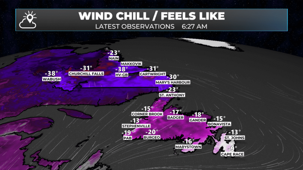
Wind chills as of 6:27 AM NST on January 27, 2026.
Good Tuesday morning!
It is cold again this morning and snow is moving in! Here are today’s weather highlights:
Another winter storm moves in today and will bring snow to much of the Island into tonight.
Yellow Level Winter Storm Warnings and Blowing Snow Advisories are in effect for the Island into tonight.
Snow will be 15 to 30 cm for much of Newfoundland today into tonight. The most intense snowfall will occur this afternoon.
Snowfall map further down in the blog post.
Wind will significantly reduce visibility this afternoon, with northerly gusts of 60 to 80 km/h in the east and northeast.
A secondary area of snow will arrive on the Northern Peninsula and the Green Bay – White Bay area tonight and continue into Wednesday. A Yellow Level Blowing Snow Advisory is in effect for those areas.
Radar shows the snow is beginning to arrive on the Island from the south. The snow will become more widespread, heavier and steadier as the day progresses. The most intense snowfall rates will occur this afternoon, on the order of 2 to 5 cm per hour. In conjunction with that, the wind speeds will ramp up, leading to very stormy conditions in exposed areas of eastern and northeastern Newfounland this afternoon and tonight. The snow will ease off overnight for many areas… but in Labrador, the Northern Peninsula, Green Bay – White Bay and possibly some areas of central (along the coast), it will continue into Wednesday. Future radar shows this well.
Today’s Breakdown By Region
Eastern Newfoundland (Avalon/Burin/Bonavista Peninsula + Clarenville)
Snow is moving in this morning and will be most impactful through the afternoon and evening. This is a cold, fluffy snow, with reduced visibility at times, especially once winds pick up later today.
Snowfall: ~15–30 cm (Avalon Peninsula will be 20 to 30 cm)
Conditions: Snow starts this morning with periods of heavy snow this afternoon, blowing and drifting snow, poor visibility in exposed areas
Temperatures: Near –3 to –5°C, cold enough for high snow ratios
Travel: Deteriorating road conditions this afternoon and evening. Conditions improve late tonight.
Southern Newfoundland
Snow has arrived, but amounts are lower than in the eastern sections. Still enough to cause slippery travel, especially during heavier bursts.
Snowfall: ~10–15 cm west of Connaigre, Connagire: 15 to 20 cm
Conditions: Steadier snow at times, generally lighter than eastern areas
Travel: Slippery roads, but less severe than the Avalon
Central Newfoundland
Snow spreads in this morning, continuing into tonight. While totals are lower than in eastern areas, cold temperatures mean snow will accumulate efficiently. The closer one gets toward Ganer, the higher the totals.
Snowfall: ~10–20 cm
Conditions: Light to moderate snow, increasing later today and tonight. Areas near the coast will see the snow linger into Wednesday from a separate system.
Travel: Gradually worsening conditions through the evening
Northeast Newfoundland
Snow arrives this morning with moderate accumulations, followed by stronger winds later, which may cause blowing snow issues.
Snowfall: ~15–20 cm (locally higher amounts possible)
Conditions: Snow this morning, becoming heavier today, then lighter tonight, but visibility issues are possible with gusts.
Winds: Gusts 60–70+ km/h later today and tonight
Travel: Blowing and drifting snow in exposed areas
West Coast
A lower-impact event compared to eastern and central areas, but still a solid snowfall by local standards.
Snowfall: ~10–15 cm
Conditions: Periods of snow today into tonight
Temperatures: Cold enough for efficient accumulation
Travel: Typical winter driving conditions, locally slick
Northern Peninsula / Green Bay – White Bay
Generally light snowfall today, with heavier snowfall in the forecast for tonight and Wednesday (possibly beyond) from a secondary system.
Snowfall: ~10–20 cm from today through Wednesday. Most falls tonight and Wednesday.
Conditions: Periods of snow today into tonight. Wind speeds pick up by Wednesday.
Temperatures: Cold enough for efficient accumulation
Travel: Typical winter driving conditions, locally slick
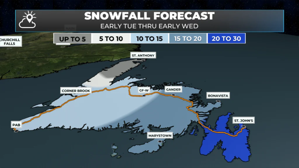
Snowfall forecast for today into early Wednesday morning. Tap to enlarge. January 27, 2026
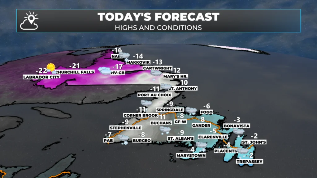
Today’s forecast – January 27, 2026
I’ll have my next update on this week’s weather later today!
📱 Get the Sheerr Weather App in the Apple App Store and Google Play Store.
🗺️ Check out the Map Room to see all the latest weather observations for the Province.
🎥 Check out the Provincial Highway Cams to see 👀 what’s going on around our highways and
Thanks Eddie! Love your detailed forecasts!!
Thanks Eddie for your update, one good thing is it’s fluffy snow, easy to shovel 👍
Thank you Eddie for the detailed forecast. Love this app.
Thanks Eddie. Very informative.
Good morning Eddie, thanks for the update. Have a great day.
Thanks Eddie,you’re the best!
Thanks for the update Eddie very informative!
Good morning Eddie,Thanks for the update…
Thanks Eddie u ate
Thanks Eddie
Thanks Eddie!!
Truly miss you on the news.
You were great at explaining
the weather which made it easy
to understand. Keep up the great work!