
Snow Continues In Parts of Labrador and northern Newfoundland through Friday…
Our latest winter storm delivered significant snowfall across parts of Newfoundland, with some regions seeing impressive totals.
Gander: 39.0 cm
Burgeo (auto): 30.4 cm
La Scie (auto): 28.2 cm
Bonavista (auto): 27.0 cm
Lethbridge: 26.0 cm (as of 8:00 A.M. NST)
Terra Nova National Park (auto): 24.1 cm
Grand Falls–Windsor: 23.9 cm
St. John’s East: 23.4 cm
St. John’s Int’l Airport: 22.8 cm
Paradise: 22.2 cm*
St. Alban’s (auto): 22.2 cm
Conception Bay South: 22.0 cm
Millertown (auto): 21.6 cm
Badger (auto): 21.4 cm
That system has now pushed east of the Avalon, but the weather story is far from over. In fact, the overall pattern has shifted, and while that means less snow for some, it also means more snow for others — particularly across Labrador and northern Newfoundland

This forecast is sponsored by CU Financial Management. Your steady hand—guiding you through every forecast, financial or otherwise.
Visit cufm.ca/forecast today for expert advice.
What’s Happening Now
As we head through the next couple of days, we’ll see multiple rounds of snow, especially north:
Snow continues across southeastern Labrador, the Northern Peninsula, and parts of central and northeast Newfoundland
This first round eases briefly, but another wave moves in Thursday night
Snow persists through Friday for areas like Green Bay, White Bay, and the Great Northern Peninsula and southeast Labrador
A final round late Friday into Saturday for the same areas looks less intense, but still adds to totals
The weather in the east and south looks generally quiet.
By Friday evening, most of this activity winds down, and the pattern finally starts to evolve.
Expected Snowfall Amounts (Now → Friday Evening)
Coastal Labrador (Cartwright, Rigolet, Hope Dale to south of Nain):
15–30 cmNorthern Peninsula:
Widespread 15–30 cm, with 30+ cm possible in higher terrainGreen Bay / White Bay:
15–30 cmCentral Newfoundland:
Generally 5–15 cmTwillingate, Change Islands, Fogo Island and thge shorelines between:
15–30 cm
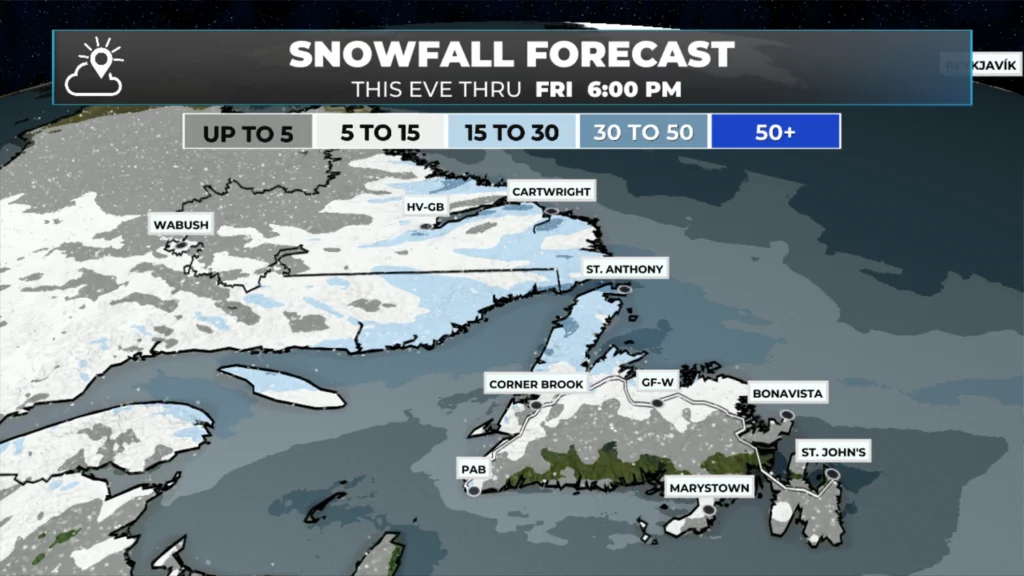
Snowfall from this evening thru Friday evening. (January 28 through January 30, 2026.
Temperature Trend: Milder Air Moves In
This stretch will be noticeably milder, especially along the coast:
Labrador coast temperatures hover near or just below freezing
Island highs mostly −2 to −4°C
Snow in many areas will be wetter and heavier, not fluffy
A gradual cool-down returns late weekend into next week
Why This Is Happening
The atmosphere is currently blocked, with high-latitude blocking near Greenland and a sluggish pattern that refuses to move quickly. That’s why the snow keeps redeveloping in the same regions.
Looking ahead, a lobe of the polar vortex over central Canada becomes the next pattern changer late this weekend. That energy helps spawn a developing storm off the U.S. East Coast, and while it’s getting a lot of attention south of the border, it will also affect Atlantic Canada.
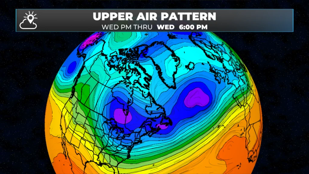
Blocking high over Greenland keeps the weather pattern slow moving until early next week…
Late Weekend / Early Next Week: What We’re Watching
Sunday night into Tuesday looks active across Newfoundland
All scenarios bring snow somewhere on the Island
Track matters:
Inside track: Greater risk of ice pellets/freezing rain/rain for parts of southern and eastern Newfoundland (including the Avalon)
Outside track: Colder solution with significant snowfall possible
There is still model disagreement, so it’s too early for precise amounts — but this system will be impactful in some form.
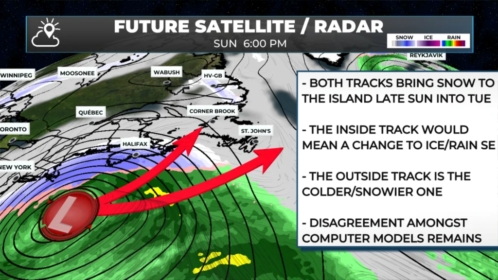
Keeping an eye on next week’s low that will move from the east seaboard of the US.
Bottom Line
Multiple rounds of snow continue through Friday
Heaviest totals focused on Labrador and northern Newfoundland
Milder temperatures mean heavier snow
A potentially significant system may impact the province Sunday into early next week
I’ll be tracking this closely and updating as confidence improves.
For real-time updates, radar, and region-by-region forecasts, make sure you have the Sheerr Weather App, available free on Apple App Store and Google Play.
I’ll have my next update posted tomorrow morning!
📱 Get the Sheerr Weather App in the Apple App Store and Google Play Store.
🗺️ Check out the Map Room to see all the latest weather observations for the Province.
🎥 Check out the Provincial Highway Cams to see 👀 what’s going on around our highways and byways!
Thanks so very much Eddie
Thanks a bunch Eddie
Thanks Eddie
Thanks Eddir