
Thursday Morning’s Weather Briefing — February 12, 2026
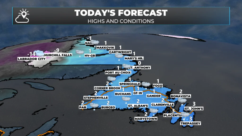
NL’s forecast for today – February 12, 2026
Good Thursday Morning!
Here are today’s weather highlights:
Snow will fly across much of NL today as an area of low pressure moves in. It’s arriving now in the south and east and will arrive a bit later farther north and west.
Snow will end by midday for much of central, eastern, and southern Newfoundland, while it continues into the overnight for the West Coast, Northern Peninsula, and Labrador.
Snowfall for most areas will be 5 to 10 cm today, with some exceptions for western Newfoundland, the GNP and coastal Labrador.
Yellow Level Warnings for Snowfall and Freezing Drizzle are still in effect at this hour from Environment Canada.
Highs will be near 0ºC for much of the Island and coastal Labrador, while areas west of Happy Valley – Goose Bay in Labrador will be closer to the minus teens.
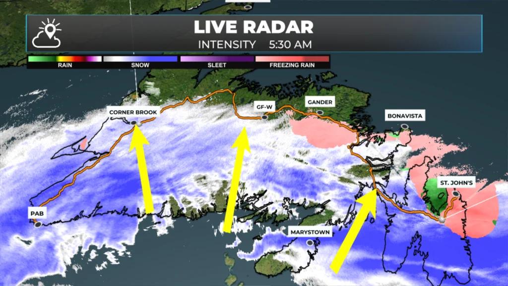
Radar image from just before 6 AM on February 12, 2026.
The group of animations above shows how the snow plays out from today through tomorrow and Saturday. Following that, the snowfall map should give you a good idea of what you can expect in your area. If you need some clarity, consult the list below.
Today’s Expected Snowfall Amounts:
Avalon Peninsula: 3 to 7 cm by midday Thursday
Bonavista Peninsula: 5 to 10 cm by midday Thursday
Burin Peninsula: 5 to 10 cm by midday Thursday
Clarenville areas and northeastern Newfoundland: 5 to 10 cm by midday Thursday
Gander and Central, Bucahns/Millertown: 5 to 10 cm by midday Thursday
Green Bay – White Bay: 10 to 15 cm by Thursday evening
South Coast / Connagire / Southwest Coast / BSG: 4 to 8 cm by Thursday evening
Southwest Coast / BSG area will pick up another 5 to 10+ cm between Thursday night and Saturday morning
West Coast: 5 to 10 cm by Thursday evening — 10 to 20 cm by Saturday morning
Northern Peninsula (eastern side): 10 to 15 cm
Northern Peninsula (western side): 5 to 10 cm
Labrador Coast: 5 to 10 cm by Thursday evening, 15 to 30 cm total by Saturday morning
Goose Bay area: 5 to 10 cm by Thursday evening, up to 15 cm by late Friday or Saturday morning
Churchill Falls: 8 to 12 cm by Thursday evening, up to 20+ cm by Saturday morning
Lab West: 2 to 5 cm by Thursday evening, up to 15 cm by Saturday morning
We are looking at a little bit of wind today, tonight and Friday as well. Coastal areas will see gusts nearing 70 to 80 km/h later today, tonight and Friday. And whlie that may sound a touch high, at least its not 100+ km/h! The Metro area will see wind speed peak later today before slowly coming down.
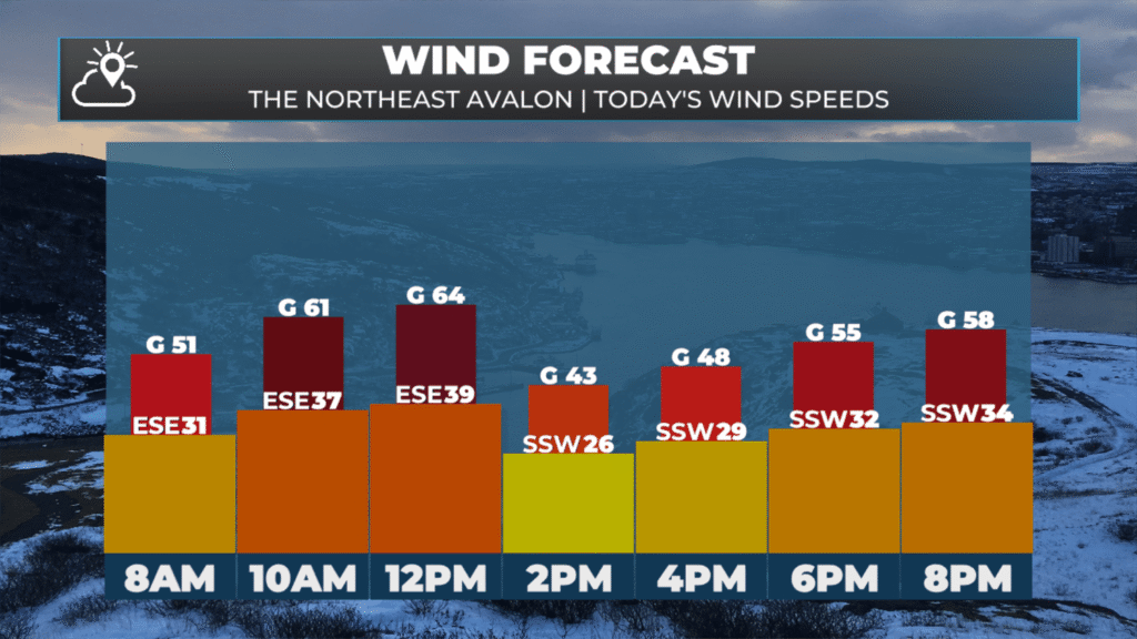
Today’s wind gust forecast for the Metro area – February 12, 2026
The rest of the Island and Labrador will see the wind speeds peak later today, tonight and Friday as our low slowly departs. The animation below shows how the wind speeds will play out in the time frame.
I’ll have updates for you throughout the day!
📱 Get the Sheerr Weather App in the Apple App Store and Google Play Store.
🗺️ Check out the Map Room to see all the latest weather observations for the Province.
🎥 Check out the Provincial Highway Cams to see 👀 what’s going on around our highways and
Thanks
Thanks for weather update Eddie
Good morning Eddie, thanks for the update. Have a great day
Good morning Eddie! Thanks for the weather update…. Enjoy your day…❄️
Good Friday ☕️morning Eddie…Thank you for the update!
Have a great day!…Stay safe