
Wednesday Morning Weather Briefing— February 18, 2026
Good Wednesday Morning
Here are today’s weather highlights:
A major winter storm arrived in eastern Newfoundland overnight, and snow continues to push back to the west this morning. The Highway Cameras show snow flying across much of the region.
Many schools, Gov NL buildings and businesses are closed, and Metrobus is suspended for the day.
Yellow and Orange Level Winter Storm Warnings are now in effect from the Avalon Peninsula to Central until late tonight or Thursday morning.
Snowfall amounts thus far — since last night:
Paradise: 47.3 cm (through 7:30 AM)
St. John’s International: 24 cm
Soundlands: 35 cm (through 6:30 AM)
Gander: 1 cm (through 6:30 AM)
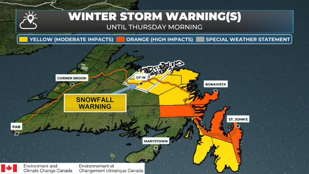
Winter Storm Alerts as of February 18, 2026 at 7:45 AM NST
Weather Alert Rundown (Full Details Here)
An Orange Level Winter Storm Warning is in effect until Thursday morning for the following areas:
St. John’s and vicinity
Avlaon Peninsula North
Clarenville and vicinity
Bonavista Peninsula
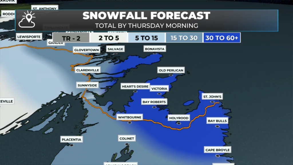
Expected snowfall: 30 to 60 cm
Expected wind gusts: Northerly as high as 100 km/h
A Yellow Level Winter Storm Warning remains in effect for the following areas until later today:
Avalon Peninsula Southeast
Avalon Peninsula Southwest
Additional snowfall: 5 to 15 cm (may mix with rain along the coast)
Expected wind gusts: Northerly as high as 100 km/h
A Yellow Level Winter Storm Warning remains in effect until Thursday morning for the following areas:
Terra Nova
Bonavista North
Gander and vicinity
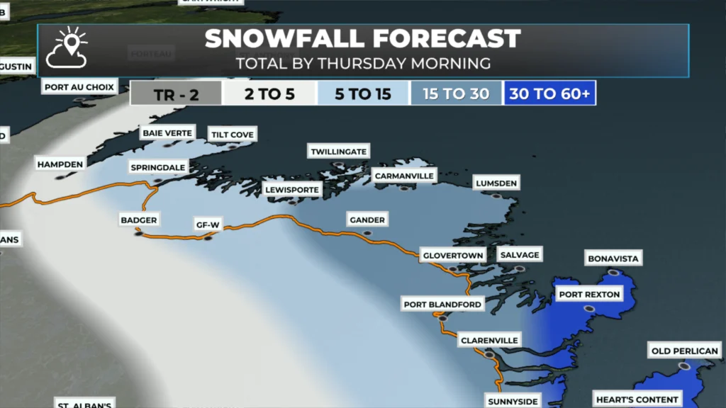
Expected snowfall: 20 to 30 cm
Expected wind gusts: 60 km/h inland and as high as 80 km/h along parts of the coast.
A Snowfall Warning is in effect for the following areas until Thursday morning:
Grand Falls-Windsor and vicinity
Bay of Exploits
Expected snowfall: 10 to 20 cm
Expected wind gusts: 50 to 60 km/h, except as high as 80 km/h along parts of the coast
Radar shows that areas of moderate to heavy snowfall are continuing to push into eastern Newfoundland this morning, around our area, as low pressure is circulating offshore and slowly moving northward. The loop below shows what has transpired over the last 6 hours.
These bands of snow will continue to lash much of eastern and northeastern Newfoundland throughout the day and into tonight. The animation below shows a future satellite and radar, which should give you an indication of how this plays out through the remainder of the day and into Thursday.
Note that there will be a lull in the snow over the Avlaon later this morning into the afternoon. The snow will then return this evening and continue into Thursday morning. The best time to clear the snow (for the first time) will be in this lull. Expect some shovel alerts.
The next image shows how the snow will accumulate through the day in the Metro area. Don’t take it as an exact amount, but more or less when it will slow down. IT shows the running totals between the time on the left and the next time to its right. The last number is the total from this morning until tomorrow afternoon. When there is no change, no further snow is expected to fall. This should give a sense of the lull I was talking about
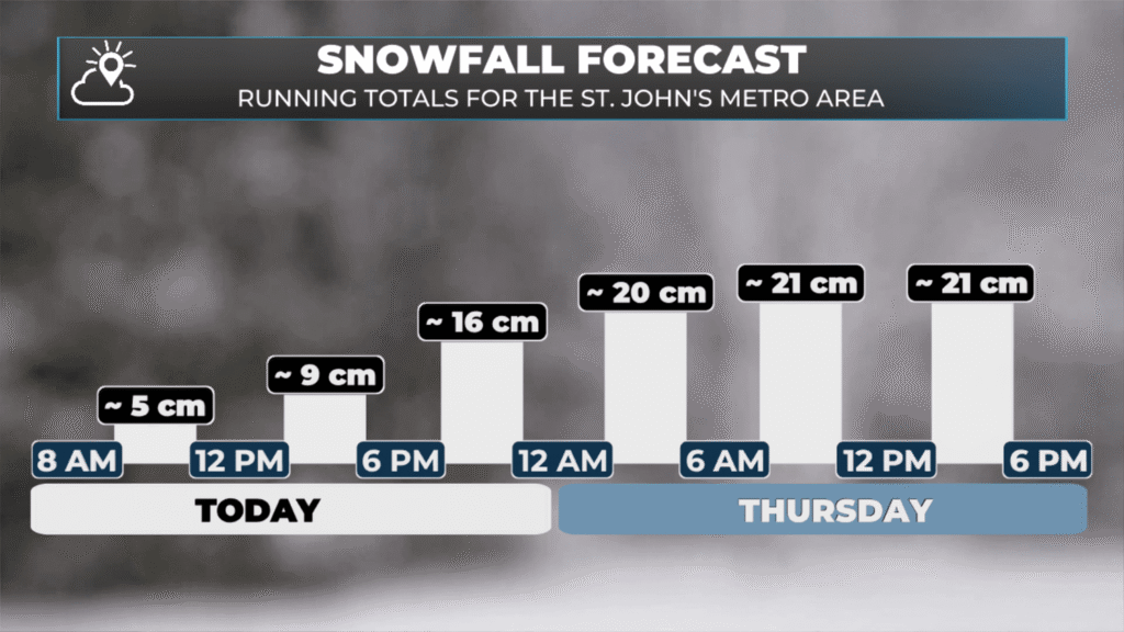
Running totals between this morning and Thursday evening. February 18 and 19, 2026. Location: St. John’s.
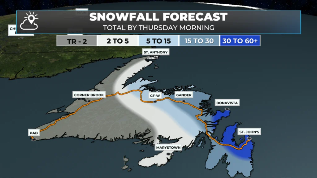
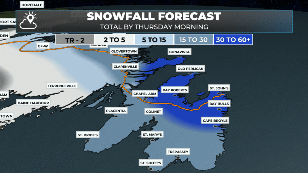
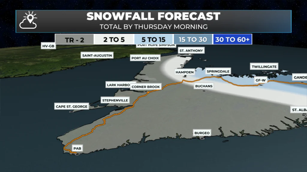
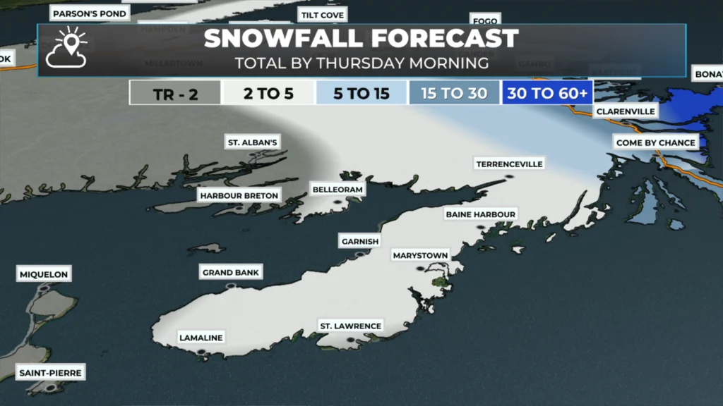
Expected snowfall totals haven’t changed (much), and below is a gallery of images showing how much will fall by the time we are all said and done. That being. I adjust the high end upwards to match what’s been seen in Paradise… where over 50 cm is a given at this point. It’s just a question of by how much. You can tap on each image to expand and swipe to see all of them.
Snowfall totals will vary GREATLY with elevation. Inland areas over higher terrain will be on the higher end of the scale, and locations near the coast will be on the lower end.
I’ll have updates to come throughout the day. Meanwhile, temperatures will hover near 0ºC on the Island today, and a few degrees cooler in Labrador. The image below shows the expected highs today.
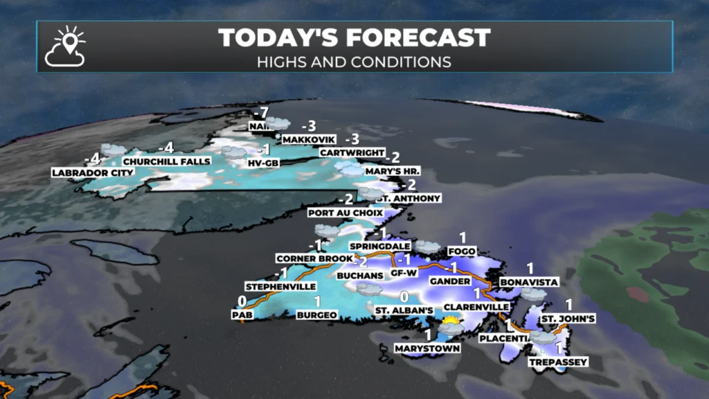
The forecast for NL for today – February 18, 2026.
Wind speeds will also gradually decrease later today and tonight as the area of low pressure moves away. The final animation of this post will show that to you nicely.
I’ll have updates for you throughout the day!
📱 Get the Sheerr Weather App in the Apple App Store and Google Play Store.
🗺️ Check out the Map Room to see all the latest weather observations for the Province.
🎥 Check out the Provincial Highway Cams to see 👀 what’s going on around our highways and
Good morning Eddie thanks for the update, Wow
Thanks Eddy.
Good morning ☕️Eddie!…Take care & Tay safe out there!
Good morning Eddie, thanks for weather update
Good morning Eddie! A nasty night and it’s still nasty out there.. a lot of shovelling needed fo’sure.
Thanks for the update, waiting now for your shovel alert.
Thanks Eddie. Waiting till noon and it should arrive here.
How does your tractor fare on heavy wet snow like this? The augers on my snowblower get clogged up and then it just rides on top of the snow. 🙁
I have been spraying my augurs and chute with wd40 when the snow is wet and heavy like this. Works for me.
Thanks Eddie. Have a great day and please place an order for a few days of warm, sunny weather, hahahaha.
Hi Eddy! Just wondering how much snow fell in Carbonear? New to the area and am used to St. John’s snow accumulations!! Thanks!
Oops !! Eddie!!!