
Thursday Morning’s Weather Briefing — February 26, 2026
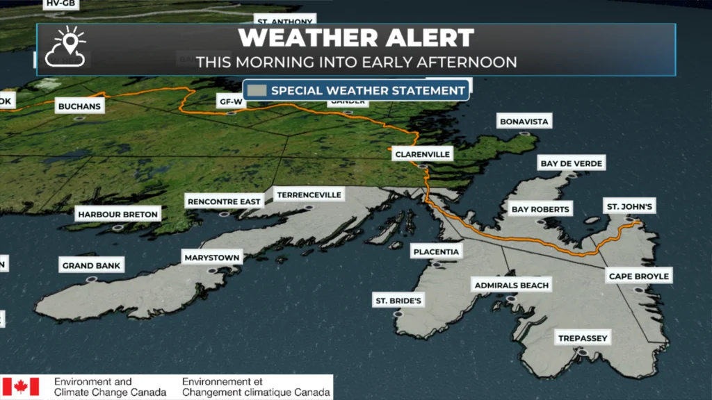
A Special Weather Statement is in effect until alter this morning for the Avalon and Burin Peninsulas for 5 to 10 cm of snow and briefly intense snowfall rates.
Good Thursday Morning!
Here are today’s weather highlights:
A Special Weather Statement is in effect for the Avalon and Burin Peninsula this morning for the threat of 5 to 10 cm of snow this morning, with rates as high as 3 to 4 cm per hour for a short time. Higher amounts are possible locally, especially over higher terrain.
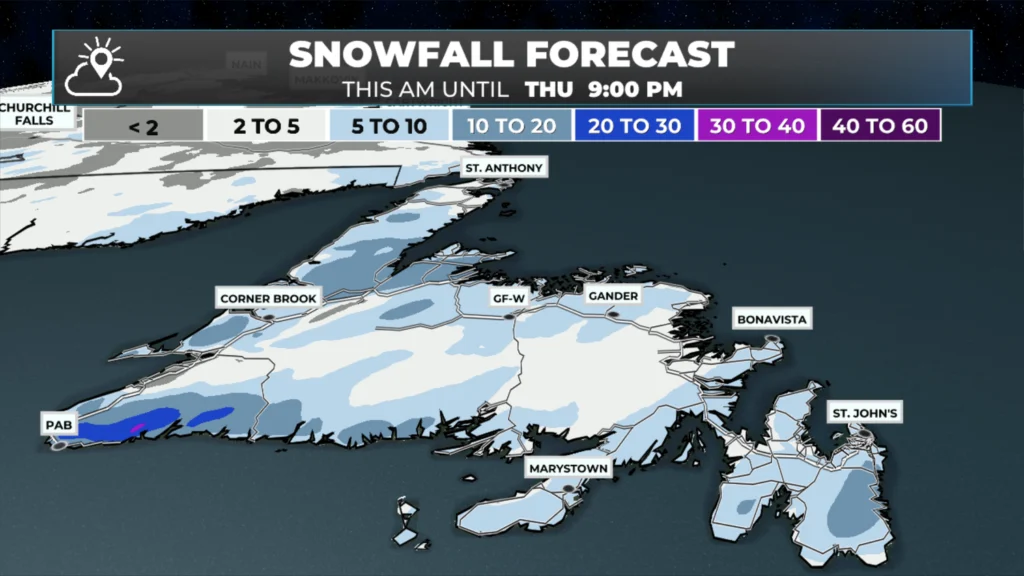
The snow today is from a quick-moving low that will bring a widespread 2 to 5 cm / 5 to 10 cm of snow to much of Newfoundland during the first half of the day.
Temperatures will be near or above freezing, which means the snow will be wet and heavy and not light and fluffy.
Snow will end as freezing drizzle over parts of the Burin and Avalon Peninsulas and some adjacent areas of eastern Newfoundland this morning.
Light snow and flurries end along the Labrador Coast later this morning, giving way to more scattered flurries throughout the day in the south and southeast.
An area of low pressure will pass southeast of the Avalon tomorrow, and it may be close enough to brush the area with some light snow or rain.
As of just before 6 AM, radar imagery shows the snow has arrived or is about to arrive on the Burin Peninsula and the extreme southwest Avalon, and over areas of western and southwestern Newfoundland. The snow will rapidly advance northward as the morning progresses. The animation below shows what the radar looked like as of this writing.
Future radar imagery shows how the precipitation will play out through the morning. Note how quickly the snow arrives and ends over the southern and eastern areas of the Island. For the Metro, it looks like it will start around 8 AM this morning and be done by about noon. This should be after most of our commute time and done before the end of the school/work day. Temperatures will also warm above freezing post-snow in the south and east, which should aid in the cleanup efforts.
Snowfall amounts are projected to be 5 to 10 cm for most of Newfoundland, with some areas slightly above (higher terrain) and some areas slightly below (south and southeast). The metro area will likely see enough snowfall today to make February the new snowiest month on record at the airport location, where data has been kept since 1942. The current record is December 2000, when 173.x cm fell. So far this month, we have seen 170.2 cm, which makes this February the snowiest February on record, surpassing 2006 when 170.1 cm of snow fell.
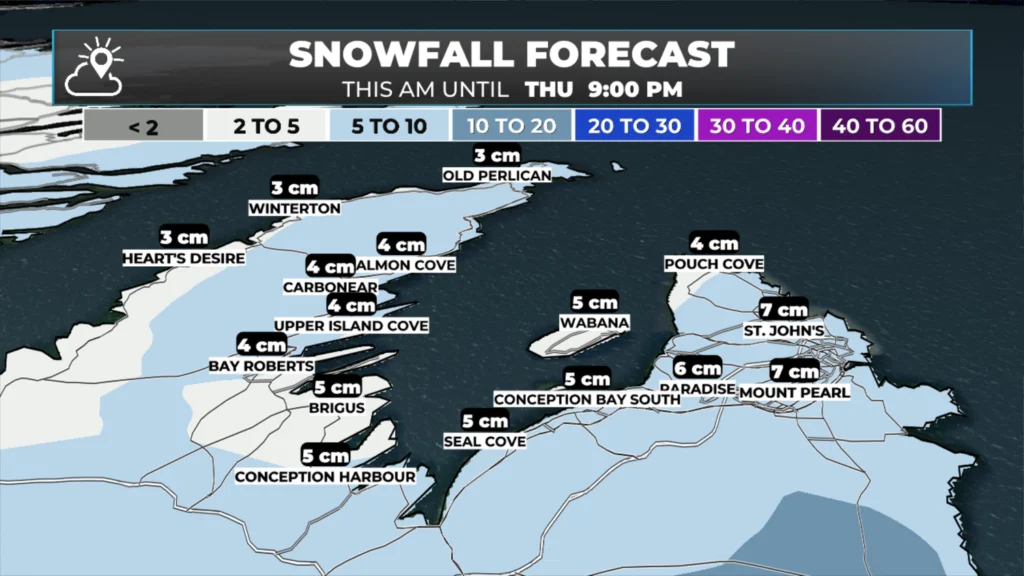
In the Metro area, snowfall will be most intense between 9 AM and just before noon. Thereafter, the snow will end quickly. The image below shows you the expected snowfall amounts per hour this morning. Note how nothing is expected this afternoon.
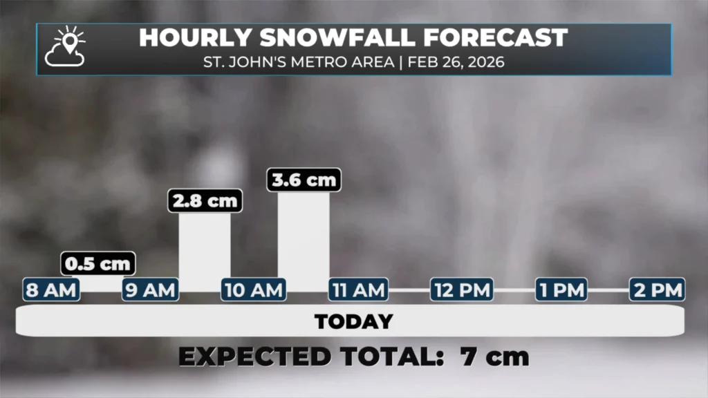
Today’s hourly snowfall amounts and the overall total for the St. John’s Metro area.
Speaking of this afternoon, temperatures across the Island will peak between near freezing and a few degrees above. Labrador will see highs today in the minus single digits to minus teens.
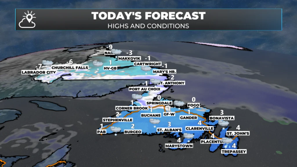
NL’s forecast for today – February 26, 2026
Friday’s weather looks quiet; however, an area of low pressure may graze eastern areas with some light rain or snow in the morning… or it may remain offshore. The next day of contention would be Sunday, when yet another low may be close enough to bring a bit more snow. Agreement on both is poor at this time — that being said, these are fast movers, so precipitation amounts will more than likely not be overly significant.
I’ll have updates for you throughout the day!
📱 Get the Sheerr Weather App in the Apple App Store and Google Play Store.
🗺️ Check out the Map Room to see all the latest weather observations for the Province.
🎥 Check out the Provincial Highway Cams to see 👀 what’s going on around our highways and
Good morning Eddie,thanks for weather update.
👍
Good morning Eddie, thanks for the update. Have a great day,
Good morning Eddie it’s definitely a month of snow, thanks for the update, have a great day
Thanks Eddie
Thanks Eddie..
Thanks Eddie.
Thanx Eddie,enjoy your day!
Good morning Eddie thanks for the update. Have a great day 😊