This morning we are off to a cooler start across much of NL compared to yesterday morning… readings on the Island are generally near or below freezing, and in Labrador it’s well below freezing with temperatures into the -20s in the west, with wind chills down to the -30s.
Observed temperatures as of 6:04 AM NST on March 11, 2026
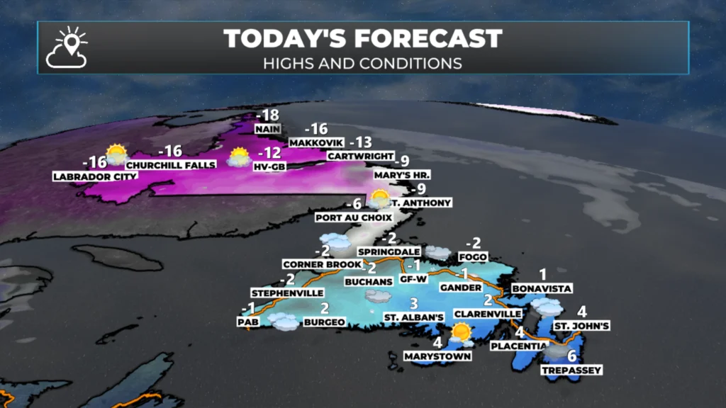
Temperatures recover today to near or above freezing by a few degrees on the Island and remain well below the goose egg in Labrador. Wind speeds will not be extraordinary, but they will be breezy enough to make things feel colder thanks to our good friend, the wind chill. Expect mostly sunny skies today, with increasing cloudiness west and southwest this afternoon.
NL’s forecast for today — March 11, 2026
Wind speeds will drop throughout the day as an area of high pressure briefly builds over the region ahead of our incoming area of low pressure for tonight and tomorrow. This will generally improve the weather, even as our system inches closer throughout the day.
The Next Storm…
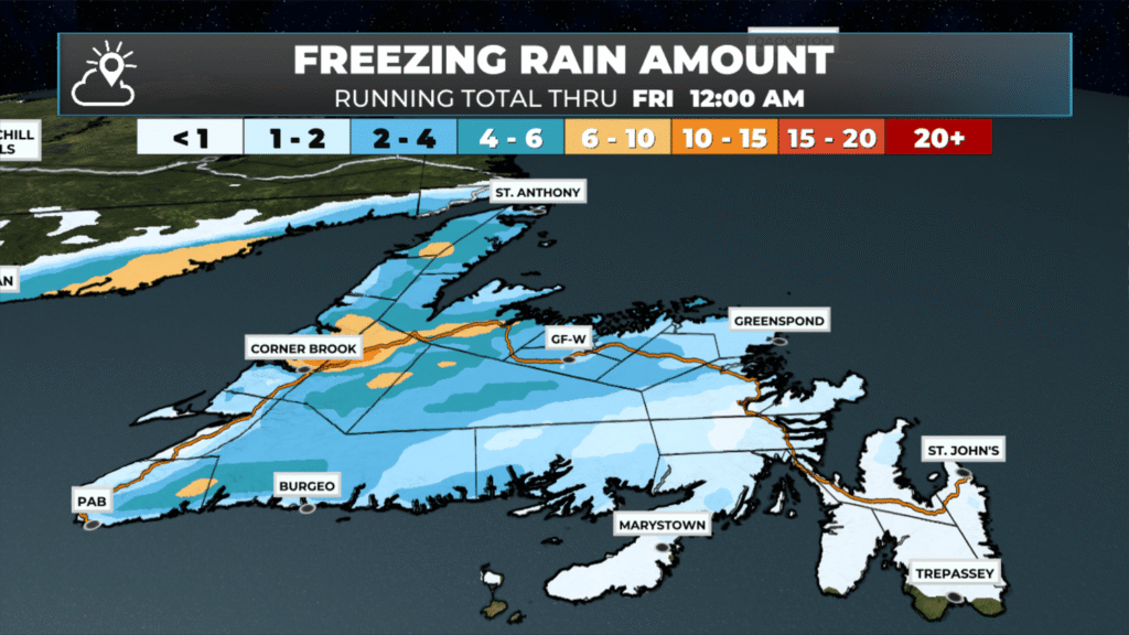
The next storm rolls in tonight, and this will be a messy one. On the Island, snow will arrive for most areas tonight, it will quickly transition to rain along the south coast, Burin and Avalon Peninsula by Thursday morning through a period of ice pellets and freezing rain. Areas farther north will see the snow last longer, along with the transition to ice pellets and freezing rain, before ultimately changing to rain during the day on Thursday. For central and western areas, it will have happened by early afternoon. However, some low-lying locations near the West Coast, through Green Bay – White Bay and then on the Northern Peninsula will see the snow and ice last much longer, particularly the freezing rain. The freezing rain is my biggest concern because it appears there will be enough in some areas to cause power outages.
The forecast for freezing rain accumulation between Wednesday evening and late Thursday night – March 11 and 12, 2026
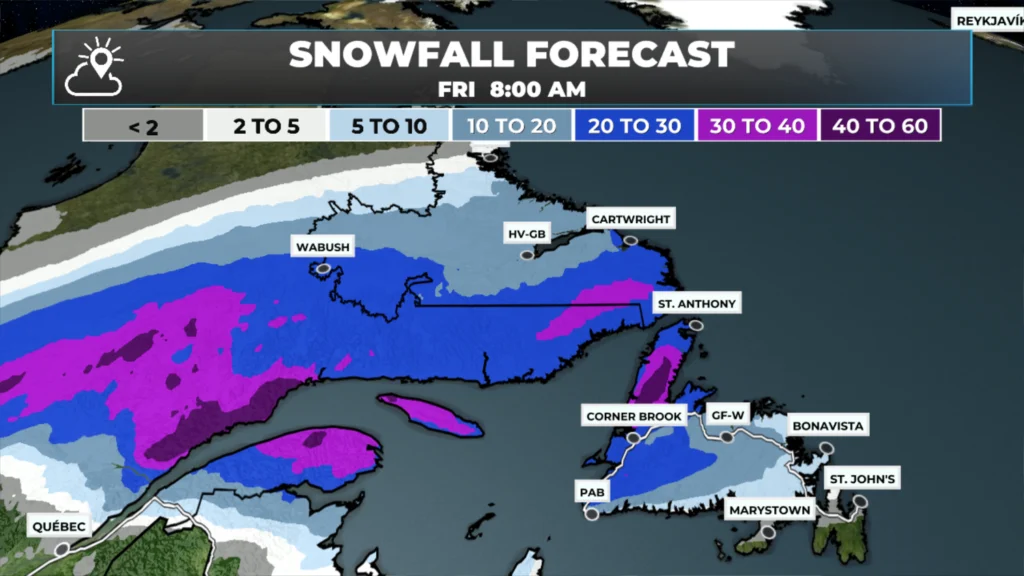
Before any change to rain, expect a widespread 15 to 30+ cm from the Great Northern Peninsula, southward to the West Coast and into Central and then farther southwest toward Bay St. George and the Port aux Basque area. East of there, snowfall amounts will be less than 15 cm; in fact, the Burin and Avalon Peninsulas will not see much at all.
Meanwhile, in Labrador, most of what falls from this will be snow, and in some areas it will be significant, with more than 40 cm on the way for some parts of the coast, but a widespread 10 to 15 cm looks likely for locations outside of the bullseye.
The snowfall forecast from late Wednesday (March 11, 2026) through Friday morning (March 13, 2026).
As the low moves near or through the Strait of Belle Isle, even the Northern Peninsula will see a full change to rain at some point later Thursday afternoon or Thursday night.
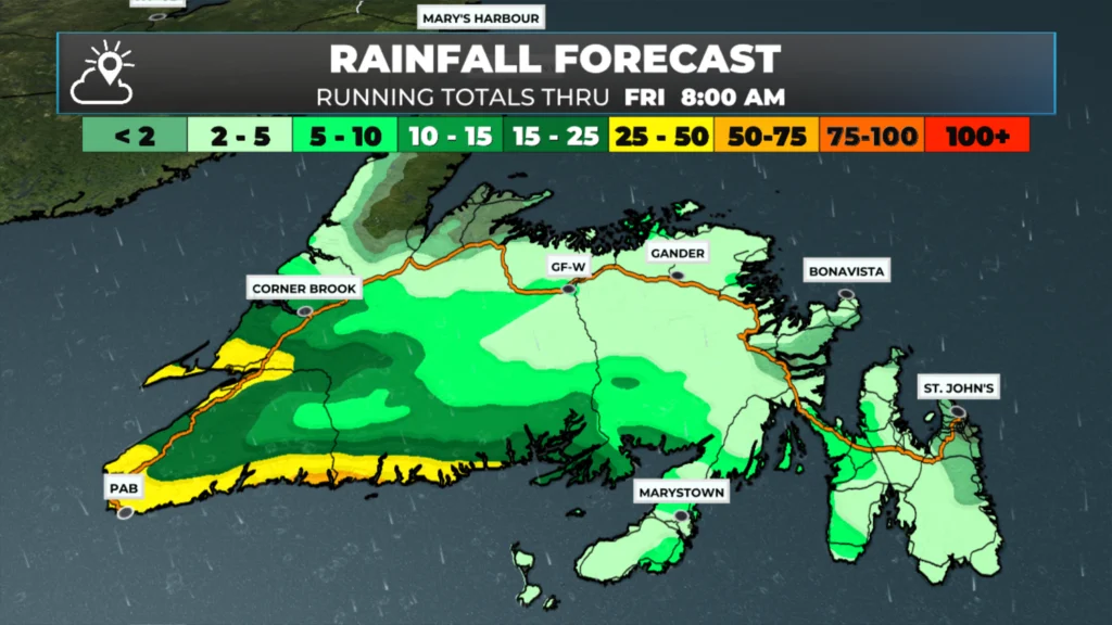
Another wave of moisture moves along the frontal boundary associated with this low between Thursdya nd Friday, which means more significant rainfall is on the way for southern and even parts of eastern Newfoundland before it all ends Friday. Significant snow melt will occur across many areas, and localized flooding will be common… I think.
The rainfall forecast from later today (March 11, 2026) through 8 AM Friday (March 13, 2026).
I’ll have my next forecast posted later today or this evening.
⚠ Storm ModeGet warnings pushed to your phone the moment they’re issued.Get the app
By using this website, you agree to our use of cookies. We use cookies to provide you with a great experience and to help our website run effectively. Privacy Policy



Thanks for the update Eddie…
Thanks Eddie for weather update
Thanks Eddie for all the updates and have a good day.
Good morning Eddie and thanks for the update, have a great day
Thanks Eddie!