
Winter Storm, Rainfall, Wind Warnings Issued by EC Ahead of Thursday’s Storm
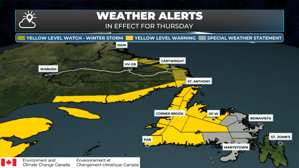
Current weather alerts from Environment Canada as of 6:34 AM on March 11, 2026.
Environment and Climate Change Canada has issued several weather alerts for Newfoundland and Labrador ahead of an incoming storm, which arrives tonight and will not fully depart until Friday. I’ve compiled a list of the latest alerts and they are as follows and include the following types:
Winter Storm Warning (Yellow Level)
Winter Storm Watch (Yellow Level)
Wreckhouse Wind Warning (Yellow Level)
Rainfall Warning (Yellow Level)
Special Weather Statement
ALERT 1 — Yellow Level Warning: Winter Storm
Issued: 5:08 AM NDT | Impact: Moderate | Confidence: High | Replaces: Yellow Level Watch — Winter Storm
Areas in effect:
Corner Brook and vicinity, N.L.
Deer Lake – Humber Valley, N.L.
Gros Morne, N.L.
Bay St. George, N.L.
Buchans and the interior, N.L.
Grand Falls-Windsor and vicinity, N.L.
Bay of Exploits, N.L.
Green Bay – White Bay, N.L.
Northern Peninsula East, N.L.
Parson’s Pond – Hawke’s Bay, N.L.
Port Saunders and the Straits, N.L.
Timeframe: Overnight tonight and Thursday.
What to expect: Hazardous winter conditions with heavy snow, freezing precipitation, and strong winds.
Total snowfall of 15–25 cm (up to 35 cm over higher terrain). Freezing rain lasting 3–6 hours with amounts of 2–5 mm (up to 10 mm locally).
Wind gusts up to 50 km/h southeasterly, rising to 80–100 km/h along parts of the coast.
After several hours of heavy snow, conditions transition to a snow/ice pellet mix Thursday morning, then freezing rain, before finally turning to rain or drizzle by Thursday afternoon or evening.
Roads and walkways will likely be difficult to navigate.
ALERT 2 — Special Weather Statement
Issued: 4:54 AM NDT
Statement continued for:
Burin Peninsula, N.L.
Connaigre, N.L.
Statement ended for:
Burgeo – Ramea, N.L.
Channel-Port aux Basques and vicinity, N.L.
Timeframe: Overnight tonight until Friday morning.
What to expect: Snow, ice pellets, freezing rain, and rainfall. Potential snowfall of 5–10 cm (2 cm or less over the Burin Peninsula).
Freezing rain lasting 2–4 hours with amounts of 2–5 mm.
Rainfall of 10–20 mm.
A period of quickly accumulating snow is expected tonight, followed by ice pellets and freezing rain, before a changeover to rain Thursday morning.
ALERT 3 —Yellow Level Warning: Rainfall
Issued: 5:27 AM NDT | Impact: Moderate | Confidence: High
Areas in effect:
Burgeo – Ramea, N.L.
Channel-Port aux Basques and vicinity, N.L.
Bay St. George, N.L.
Timeframe: Thursday and Thursday night.
What to expect: Significant rainfall following a period of snow, ice pellets, and freezing rain.
Total rainfall of 15–25 mm, with up to 50 mm possible in Burgeo–Ramea. Rainfall rates of 5–10 mm/hr possible.
Significant runoff likely due to recent snowmelt and frozen ground — localized flooding in low-lying areas, and streams and rivers may run significantly higher than normal.
Water will likely pool on roads and in low-lying areas. Allow extra time for travel.
ALERT 4 — Yellow Level Warning: Wreckhouse Wind
Issued: 4:56 AM NDT | Impact: Moderate | Confidence: High
Areas in effect:
Channel-Port aux Basques and vicinity, N.L.
What to expect: Very strong wind gusts expected in the Wreckhouse area, with southeasterly gusts up to 130 km/h. High-sided vehicles will be pushed around by the wind. Disruptions to services and travel are possible.
Timeframe: Thursday morning.
ALERT 5 — Yellow Level Warning: Winter Storm (Labrador)
Issued: 5 AM ADT | Impact: Moderate | Confidence: High Replaces: Yellow Level Watch — Winter Storm
Areas in effect:
Red Bay to L’Anse-au-Clair, N.L.
Timeframe: Thursday morning until late overnight Thursday night.
What to expect: Hazardous winter conditions expected. Total snowfall of 15–25 cm with locally higher amounts possible. Freezing rain lasting 2–4 hours with amounts of 2–5 mm.
Easterly wind gusts up to 80 km/h.
After several hours of snow and blowing snow (heavy at times), the snow will transition to a mix of snow and ice pellets late Thursday, then a brief period of freezing rain Thursday evening, before tapering to flurries overnight.
Travel will likely be challenging — consider postponing non-essential travel and outdoor activities until conditions improve.
ALERT 6 — Yellow Level Watch: Winter Storm (Labrador)
Issued: 5:14 AM ADT| Impact: Moderate | Confidence: High
Areas in effect:
Norman Bay to Lodge Bay, N.L.
Cartwright to Black Tickle, N.L.
Rigolet and vicinity, N.L.
Postville – Makkovik, N.L.
Timeframe: Thursday afternoon until Friday evening.
What to expect: Significant snowfall, strong winds, and blowing snow are likely along the Labrador Coast from Lodge Bay to Makkovik. Potential snowfall of 20–40 cm with locally higher amounts.
Wind gusts northeasterly 60–80 km/h shifting to northwesterly 80–100 km/h.
There is some uncertainty as to where the heaviest snow will fall, but significant accumulations are possible over some locations.
Adverse travel conditions expected — consider modifying travel plans, and if travel is necessary, allow extra time. Prepare for possible disruptions to transportation, services, and utilities.
Is the special weather statement for Bonavista Peninsula, too? Looks so in graphic, but not seeing it in the narrative.
Good catch. There is a second one that is not listed there.