
Thursday Morning’s Weather Briefing — March 19, 2026
Good Thursday morning! Here are today’s weather highlights:
We are off to a COLD start this morning!
The weather today will be quiet across NL as a high-pressure centre builds in.
Snow is in the forecast for the Avalon and some eastern areas of the Island from late this evening into Friday morning. Amounts look to be in the 5 to 15 cm range for the Avalon, with lesser amounts to the west.
This could be enough snow to bring some delays to schools/work and flights Friday morning… especially along the Southern Shore and into the Metro area.
Today’s Outlook for NL
We are off to a cold start this morning, with temperatures across the Province ranging from the single digits below freezing on the Island to nearly -35ºC in Labrador West. Wind chills are into the minus teens, -20s and -30s as we begin the day. However, unlike the last few days, we are looking at dry conditions across Newfoundland and Labrador at this hour, minus a few isolated flurries along and near the West Coast.
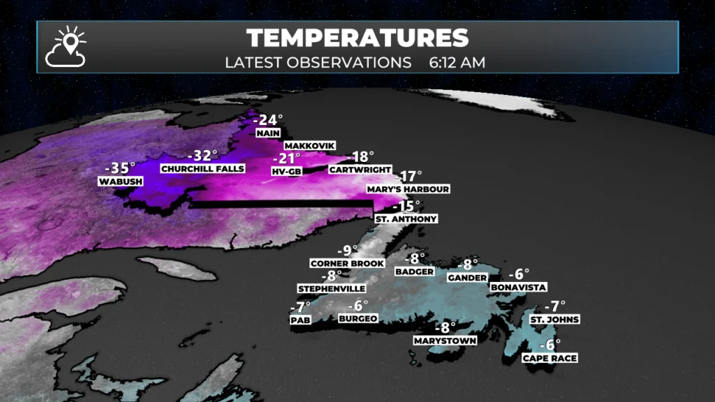
Observed temperatures across NL as of 6:12 AM NDT
For today, we can expect mostly sunny skies over Labrador and the majority of Newfoundland. The exception, surprise-surprise, will be on the Avalon, where skies look to remain mostly cloudy thanks to an area of low pressure offshore. Temperatures will peak at near -3ºC across much of the Island, with colder readings on the Northern Peninsula. High temperatures in Labrador will slowly rise into the minus teens after a bitterly cold start this morning.
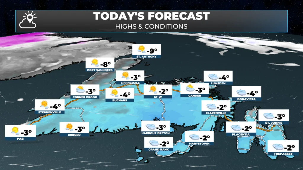
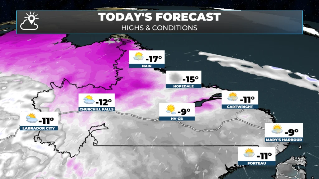
Snow Tonight into Friday?!

An area of low pressure will pass east of the Avalon Peninsula between tonight and midday Friday. At this point, the low will be close enough to bring a 5 to 15 cm snowfall to the easternmost Peninsula between tonight and mid-morning Friday. The highest amounts (~15 cm) will be found near the Southern Shore and possibly into the St. John’s Metro. Very little snow will fall west of the Avalon; however, areas like Clarenville and the Bonavista Peninsula will likely see at least a little bit.
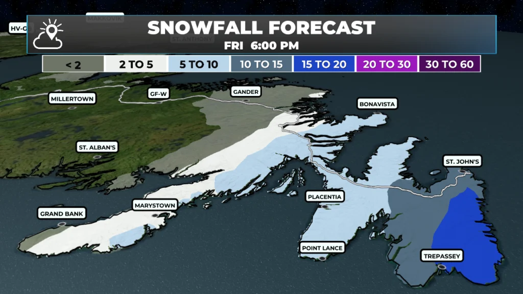
Snowfall forecast from the evening of March 19 to March 20, 2026
While this will not be a major snowfall, it will likely be enough to impact travel plans on Friday morning and could cause delays or school closures. If you have a flight Friday morning, I have a sneaking suspicion there may be some delays, as the flights slated to arrive tonight may not make it, and consequently there may not be airplanes here for the first few flights of the day tomorrow. Check with your carrier for changes to your schedule. The animation below shows the arrival and departure of the snow.
Outside of that, the weather on Friday looks pretty quiet across NL. I’ll have my next forecast posted this afternoon, so be sure to check back here for updates, and also don’t forget to look at the link below!
📱 Get the Sheerr Weather App in the Apple App Store and Google Play Store.
🗺️ Check out the Map Room to see all the latest weather observations for the Province.
🎥 Check out the Provincial Highway Cams to see 👀 what’s going on around our highways and
Good Morning Eddie! Thanks for update, although it hasn’t made me feel any happier about our weather. Please give us ample notice when you see even just a glimmer of potential sunshine in our area. Enjoy your day!
I will try my best!
Thanks Eddie for weather update
Very welcome!
Thank you for the weather update.
Good morning Eddie and thanks for the update
Eddie I was hoping it was behind us. But being a born and bred newfie I should know better!